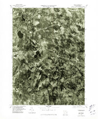
1975 Map of Peru
USGS Topo · Published 1981About this map
The town of Peru sits at the heart of this mid-1970s orthophotoquad, showing the wooded Berkshire landscape through direct aerial imagery. The settlement pattern here is characterized by sparse clusters of homes and winding roads, reflecting the region's rural character. To the west, the village of Hinsdale borders the larger waters of Ashmere Lake, which dominates the central portion of the map with its irregular shoreline. Further north, the Windsor Reservoir provides a substantial water catchment within the dense forest cover. This photographic survey, produced by the Department of the Interior, captures the exact state of the land and forest management in the mid-seventies, including the smaller Garnet Lake to the south. The use of rectified photoimagery instead of traditional topographic contours offers a raw look at the vegetation density and field boundaries during this period.
Find a feature on this map
5 named features on this map. Tap any name to fly to it.
Don’t see what you’re looking for? This feature index may not catch every label — zoom into the map to look around manually.
Map Details
Editions of this 1975 Peru Map
This is the sole edition of this map. No revisions or reprints were ever made.
Other maps of this area

1886 · Greylock
USGS Topo · 1:62,500

1886 · Hawley
USGS Topo · 1:62,500

1886 · Chesterfield
USGS Topo · 1:62,500

1886 · Becket
USGS Topo · 1:62,500

1888 · Becket
USGS Topo · 1:62,500

1888 · Chesterfield
USGS Topo · 1:62,500

1890 · Hawley
USGS Topo · 1:62,500

1891 · Greylock
USGS Topo · 1:62,500

1893 · Chesterfield
USGS Topo · 1:62,500

1893 · Becket
USGS Topo · 1:62,500