1913 Map of Peterstown
USGS Topo · Published 1913About this map
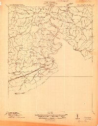
Peterstown and the southern West Virginia borderlands are defined by the winding course of the New River and the rugged industrial infrastructure of the Norfolk and Western Railroad in 1913. The rail line follows the East River through the southern portion of the sheet, marked by technical landmarks like the Hales Gap Tunnel. This era shows a landscape densely populated with small rural institutions, including an unusual number of named schoolhouses such as Mudhole School, Scratch Gravel School, and Possum Hollow School, which reveal the decentralized nature of early 20th-century mountain communities.
Find a feature on this map
108 named features on this map. Tap any name to fly to it.
Don’t see what you’re looking for? This feature index may not catch every label — zoom into the map to look around manually.
Map Details
Editions of this 1913 Peterstown Map
This is the sole edition of this map. No revisions or reprints were ever made.
Other maps of this area

1887 · Pocahontas
USGS Topo · 1:125,000

1887 · Hinton
USGS Topo · 1:125,000

1890 · Dublin
USGS Topo · 1:125,000

1891 · Pocahontas
USGS Topo · 1:125,000

1891 · Dublin
USGS Topo · 1:125,000

1891 · Raleigh
USGS Topo · 1:125,000

1892 · Hinton
USGS Topo · 1:125,000

1894 · Pocahontas
USGS Topo · 1:125,000

1895 · Pocahontas
USGS Topo · 1:125,000

1897 · Raleigh
USGS Topo · 1:125,000