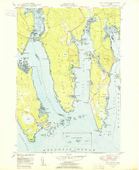
1950 Map of Petit Manan
USGS Topo · Published 1950About this map
Corea serves as a focal point for this coastal survey of the jagged Down East shoreline, where the village and its Corea Harbor are defined by the intricate relationship between the land and the Atlantic. The landscape is dominated by expansive areas of Heath and numerous protected inlets such as Dyer Harbor and Joy Bay. Topographic details reveal the importance of local navigation and fishing, with dozens of named ledges, coves, and points like Dolly Head and Rogers Point marking the granite-bound coast. Notable genealogical sites include the Corea Cem and a Spire in the settlement. The map also captures the complex hydrography of the Sally Islands and Petit Manan Point, using data from surveys dating back to 1870. This intersection of early hydrographic soundings and mid-century aerial photography provides a window into the maritime character of eastern Maine.
Find a feature on this map
107 named features on this map. Tap any name to fly to it.
Don’t see what you’re looking for? This feature index may not catch every label — zoom into the map to look around manually.
Map Details
Editions of this 1950 Petit Manan Map
This is the sole edition of this map. No revisions or reprints were ever made.
Other maps of this area

1902 · Cherryfield
USGS Topo · 1:62,500

1904 · Cherryfield
USGS Topo · 1:62,500

1904 · Bar Harbor
USGS Topo · 1:62,500

1904 · Petit Manan
USGS Topo · 1:62,500

1921 · Great Wass Island
USGS Topo · 1:62,500

1921 · Columbia Falls
USGS Topo · 1:62,500

1930 · Tunk Lake
USGS Topo · 1:48,000

1932 · Tunk Lake
USGS Topo · 1:62,500

1941 · Columbia Falls
USGS Topo · 1:62,500

1942 · Bar Harbor
USGS Topo · 1:62,500