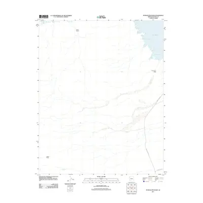
2011 Map of Petroglyph Wash
USGS Topo · Published 2011About this map
Lake Mead defines the northern and eastern fringes of this Mojave County landscape, where the desert floor meets the irregular indentations of the Colorado River's impounded waters. The map details a series of distinct inlets along the reservoir, including Canyon Point Cove, Sidewinder Cove, James Bay, and Teakettle Bay. Inland, the terrain is dominated by the drainage system of Petroglyph Wash, which carves a path through the arid flats toward Petroglyph Bay. To the west, the rising elevations of Wilson Ridge overlook the basin, while Wildhorse Spring marks a rare water source in the southern sector. Transportation is limited to a few arterial routes such as Bonelli Landing Rd, reflecting the remote character of this region. This survey captures the relationship between the engineered shoreline of the lake and the ancient natural features like Gilbert Canyon that predate the reservoir.
Find a feature on this map
12 named features on this map. Tap any name to fly to it.
Don’t see what you’re looking for? This feature index may not catch every label — zoom into the map to look around manually.
Map Details
Editions of this 2011 Petroglyph Wash Map
This is the sole edition of this map. No revisions or reprints were ever made.
Other maps of this area

1886 · Camp Mohave
USGS Topo · 1:250,000

1886 · Saint Thomas
USGS Topo · 1:250,000

1892 · Camp Mohave
USGS Topo · 1:250,000

1893 · Saint Thomas
USGS Topo · 1:250,000

1926 · Nelson
USGS Topo · 1:96,000

1926 · Bonelli
USGS Topo · 1:96,000

1926 · Boulder Canyon
USGS Topo · 1:96,000

1942 · Camp Mohave
USGS Topo · 1:250,000

1947 · Kingman
USGS Topo · 1:250,000

1948 · Kingman
USGS Topo · 1:250,000