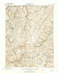
1913 Map of Pickens
USGS Topo · Published 1963About this map
Helvetia and Pickens anchor this study of the upper Buckhannon River and Tygart River headwaters before the First World War. The region's industrial character is defined by the B and O RR and a network of Lumber RR lines that push into the high timber of Beech Mountain and Turkeybone Mountain. These rail corridors were essential for moving resources out of the high Allegheny elevations, connecting remote camps like Burtridge and Bennetts Camp to larger markets.
Find a feature on this map
115 named features on this map. Tap any name to fly to it.
Don’t see what you’re looking for? This feature index may not catch every label — zoom into the map to look around manually.
Map Details
Editions of this 1913 Pickens Map
4 editions found

Other maps of this area

1889 · Beverly
USGS Topo · 1:125,000

1891 · Huntersville
USGS Topo · 1:125,000

1892 · Beverly
USGS Topo · 1:125,000

1893 · Buckhannon
USGS Topo · 1:125,000

1894 · Huntersville
USGS Topo · 1:125,000

1896 · Buckhannon
USGS Topo · 1:125,000

1897 · Buckhannon
USGS Topo · 1:125,000

1901 · Monterey
USGS Topo · 1:125,000

1909 · Elkins
USGS Topo · 1:62,500

1912 · Sago
USGS Topo · 1:48,000