2024 Map of Pine Mountain
USGS Topo · Published 2024About this map
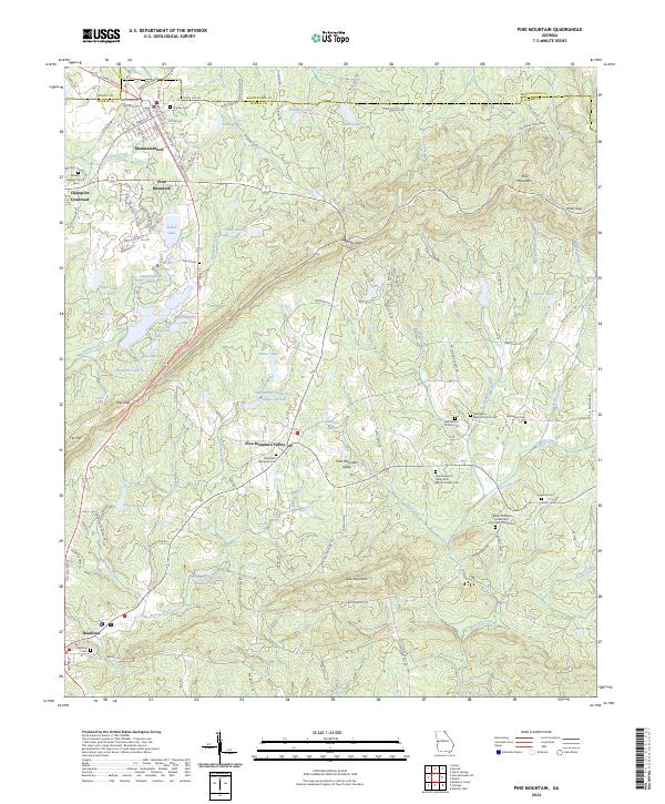
The ridge of Pine Mountain dominates this landscape in Harris County, Georgia, providing a backdrop for a series of small rural communities and organized agricultural layouts. The settlement of Pine Mountain Valley stands out with its distinctively regular road grid, including Hamilton Rd and Dallas Mill Rd, while the older town of Hamilton serves as a southern anchor. This area is characterized by an exceptional density of family and community burial grounds, such as the Roosevelt Memorial Cem and Whitehead Cem, indicating a long-established residential history. The topography is defined by significant passes through the ridges, most notably Kings Gap and Hog Gap, which dictate the local transport patterns. Hydrological features are plentiful, ranging from major water bodies like Robin Lake and Lake Delano to smaller creeks like Turkey Creek and Beaver Creek that drain the valleys between the prominent mountain peaks.
Find a feature on this map
139 named features on this map. Tap any name to fly to it.
Don’t see what you’re looking for? This feature index may not catch every label — zoom into the map to look around manually.
Map Details
Editions of this 2024 Pine Mountain Map
This is the sole edition of this map. No revisions or reprints were ever made.
Historical Maps of Pine Mountain Through Time
Featured Locations
- Hamilton, GA
- Pine Mountain, GA
- Pine Mountain Valley, GA
- Champion Crossroad, GA
- Mountainbrook, Pine Mountain