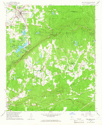
1964 Map of Pine Mountain
USGS Topo · Published 1966About this map
Pine Mountain and Oak Mountain dominate this mid-century landscape where the Central of Georgia railroad cuts through the terrain. The map captures a unique moment in the development of Western Georgia’s resort and conservation areas, notably the extensive grounds of Callaway Gardens with its numerous bird-named water bodies like Mockingbird Lake and Bluebird Lake. To the east, the Franklin D Roosevelt State Park spans the ridge, featuring landmarks such as Kings Gap and the Roosevelt Memorial Chapel.
Find a feature on this map
64 named features on this map. Tap any name to fly to it.
Don’t see what you’re looking for? This feature index may not catch every label — zoom into the map to look around manually.
Map Details
Editions of this 1964 Pine Mountain Map
This is the sole edition of this map. No revisions or reprints were ever made.
Other maps of this area

1907 · Talbotton
USGS Topo · 1:125,000

1934 · Warm Springs
USGS Topo · 1:62,500

1936 · Warm Springs
USGS Topo · 1:62,500

1950 · Mulberry Grove
USGS Topo · 1:24,000

1950 · Waverly Hall
USGS Topo · 1:24,000

1950 · Cataula
USGS Topo · 1:24,000

1950 · Talbotton
USGS Topo · 1:62,500

1950 · Ellerslie
USGS Topo · 1:62,500
1955 · Mulberry Grove
USGS Topo · 1:24,000
1955 · Waverly Hall
USGS Topo · 1:24,000
Featured Places
- Pine Mountain, GA
- Hamilton, GA
- Pine Mountain Valley, GA
- Champion Crossroad, GA
- Mountainbrook, Pine Mountain