1912 Map of Pineville
USGS Topo · Published 1912About this map
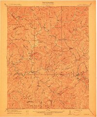
The Guyandot River winds through a landscape defined by sharp ridges and deep hollows in this 1912 topographical study of Wyoming County. Local settlements like Pineville, the county seat, and Baileysville serve as primary anchors along the river's course, while smaller outposts such as Oceana and Jesse are scattered through the tributary valleys. The survey captures the region just as the industrial era began to reshape the Southern West Virginia coalfields, though the landscape here remains characterized by family-named landmarks and natural features like Huff Mountain and Micajah Ridge.
Find a feature on this map
136 named features on this map. Tap any name to fly to it.
Don’t see what you’re looking for? This feature index may not catch every label — zoom into the map to look around manually.
Map Details
Editions of this 1912 Pineville Map
This is the sole edition of this map. No revisions or reprints were ever made.
Other maps of this area

1887 · Pocahontas
USGS Topo · 1:125,000

1891 · Tazewell
USGS Topo · 1:125,000

1891 · Pocahontas
USGS Topo · 1:125,000

1891 · Oceana
USGS Topo · 1:125,000

1891 · Raleigh
USGS Topo · 1:125,000

1893 · Oceana
USGS Topo · 1:125,000

1894 · Pocahontas
USGS Topo · 1:125,000

1895 · Tazewell
USGS Topo · 1:125,000

1895 · Pocahontas
USGS Topo · 1:125,000

1897 · Tazewell
USGS Topo · 1:125,000