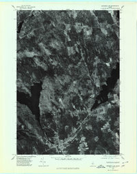
1975 Map of Pittsfield NW
USGS Topo · Published 1980About this map
Great Moose Lake and the winding Sebasticook River define this rural Somerset County landscape during the mid-1970s. This orthophotoquad provides an aerial perspective of the region's transition from water to woodland, centering on the small village of St Albans and the northern edge of Hartland. The imagery reveals a patchwork of forest and cleared fields characteristic of central Maine’s agricultural and timber-linked economy. High ground is marked by St Albans Mountain in the north, while water bodies like Indian Pond and the point labeled Stronghold indicate the area's geography of interconnected lakes and streams. Other smaller clusters of settlement, including West Ripley, appear as concentrated dots of infrastructure amidst the dense vegetation and hydrography captured in this October 1975 flyover.
Find a feature on this map
8 named features on this map. Tap any name to fly to it.
Don’t see what you’re looking for? This feature index may not catch every label — zoom into the map to look around manually.
Map Details
Editions of this 1975 Pittsfield NW Map
This is the sole edition of this map. No revisions or reprints were ever made.
Other maps of this area

1913 · Skowhegan
USGS Topo · 1:62,500

1930 · Pittsfield
USGS Topo · 1:48,000

1932 · Pittsfield
USGS Topo · 1:62,500

1933 · Pittsfield
USGS Topo · 1:62,500

1933 · Guilford
USGS Topo · 1:62,500

1937 · Guilford
USGS Topo · 1:62,500

1948 · Bangor
USGS Topo · 1:250,000

1948 · Kingsbury
USGS Topo · 1:62,500

1950 · Kingsbury
USGS Topo · 1:62,500

1954 · Millinocket
USGS Topo · 1:250,000