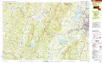
1998 Map of Pittsfield West
USGS Topo · Published 2000About this map
The Taconic Mountains and the Massachusetts-New York border define this landscape, where the urban edge of Pittsfield meets the protected ridges of Pittsfield State Forest. On the eastern side, the city's growth is marked by institutions like Berkshire Community College, Taconic High Sch, and the Pittsfield Municipal Airport, while substantial water bodies such as Onota Lake and Richmond Pond anchor the valley floor. To the west, the topography rises sharply toward Perry Peak and the Bates Memorial State Park.
Find a feature on this map
54 named features on this map. Tap any name to fly to it.
Don’t see what you’re looking for? This feature index may not catch every label — zoom into the map to look around manually.
Map Details
Editions of this 1998 Pittsfield West Map
This is the sole edition of this map. No revisions or reprints were ever made.
Other maps of this area

1886 · Greylock
USGS Topo · 1:62,500

1886 · Becket
USGS Topo · 1:62,500

1888 · Becket
USGS Topo · 1:62,500

1888 · Berlin
USGS Topo · 1:62,500

1888 · Pittsfield
USGS Topo · 1:62,500

1890 · Pittsfield
USGS Topo · 1:62,500

1890 · Berlin
USGS Topo · 1:62,500

1891 · Greylock
USGS Topo · 1:62,500

1893 · Troy
USGS Topo · 1:62,500

1893 · Becket
USGS Topo · 1:62,500