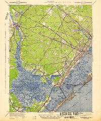
1942 Map of Pleasantville
USGS Topo · Published 1942About this map
Pleasantville and the surrounding marshlands of Atlantic County dominate this wartime survey, showing the intricate network of tidal channels and inland settlements just prior to mid-century development. The landscape is defined by the Great Egg Harbor Bay and the winding course of the Great Egg Harbor River, where riverfront hamlets like Catawba and Estellville sit near the edge of the Estell Manor territory. The rail-and-road infrastructure of the era is clearly marked by the Pennsylvania Reading Seashore Lines and prominent thoroughfares such as the White Horse Pike and Black Horse Pike, which facilitated travel between the mainland and coastal destinations like Ocean City and Longport. Genealogists and local historians can trace the older footprints of smaller crossroads like Scullville, Bargaintown, and English Creek, alongside early aviation and maritime markers including the Great Egg C G S station.
Find a feature on this map
94 named features on this map. Tap any name to fly to it.
Don’t see what you’re looking for? This feature index may not catch every label — zoom into the map to look around manually.
Map Details
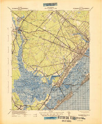
Editions of this 1942 Pleasantville Map
2 editions found
Other maps of this area

1884 · Sea Isle
USGS Topo · 1:62,500

1887 · Atlantic City
USGS Topo · 1:62,500

1888 · Dennisville
USGS Topo · 1:62,500

1888 · Little Egg Harbor
USGS Topo · 1:62,500

1888 · Sea Isle
USGS Topo · 1:62,500

1890 · Great Egg Harbor
USGS Topo · 1:62,500

1890 · Hammonton
USGS Topo · 1:62,500

1890 · Tuckahoe
USGS Topo · 1:62,500

1890 · Mullica
USGS Topo · 1:62,500

1893 · Great Egg Harbor
USGS Topo · 1:62,500