1909 Map of Pocahontas Special
USGS Topo · Published 1909About this map
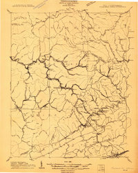
The Norfolk and Western RR winds through the heart of the Pocahontas coalfields, connecting industrial outposts along Elkhorn Creek during a period of intense development. This survey, conducted in cooperation with the State of West Virginia, reveals the dense network of mining settlements and rail junctions like Algoma Junc, Switchback P O, and Worth P O. The topography is dominated by massive divides such as Barkers Ridge and Pinnacle Ridge, which separate the rugged headwaters of the Bluestone River from the northern creek systems. Settlements like Bramwell and Keystone appear as established hubs in a landscape otherwise defined by company towns and steep mountain passes like Peeled Chestnut Gap. The map captures the specialized rail-and-river economy of the era, where every hollow and gap served as a conduit for the region's mineral wealth.
Find a feature on this map
139 named features on this map. Tap any name to fly to it.
Don’t see what you’re looking for? This feature index may not catch every label — zoom into the map to look around manually.
Map Details
Editions of this 1909 Pocahontas Special Map
This is the sole edition of this map. No revisions or reprints were ever made.
Other maps of this area

1887 · Pocahontas
USGS Topo · 1:125,000

1891 · Tazewell
USGS Topo · 1:125,000

1891 · Pocahontas
USGS Topo · 1:125,000

1891 · Oceana
USGS Topo · 1:125,000

1891 · Raleigh
USGS Topo · 1:125,000

1893 · Oceana
USGS Topo · 1:125,000

1894 · Pocahontas
USGS Topo · 1:125,000

1895 · Tazewell
USGS Topo · 1:125,000

1895 · Pocahontas
USGS Topo · 1:125,000

1897 · Tazewell
USGS Topo · 1:125,000