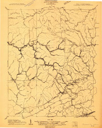
1911 Map of Pocahontas Special
USGS Topo · Published 1911About this map
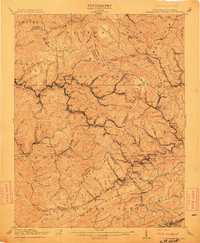
The Norfolk & Western RR snakes through the deep valleys of the West Virginia coalfields, serving a dense string of company towns and industrial settlements just after the turn of the century. Settlements like Keystone, North Fork, Landgraff, and Eckman cling to the narrow corridors of Elkhorn Creek and its tributaries, illustrating the rapid development driven by the region's mineral wealth. High above the valley floors, the terrain is dominated by the massive Flat Top Mountain and ridges such as Beartown Ridge and Indian Ridge. This 1909 survey records the presence of localized post offices and small stations like Bearwallow Worth PO, Mora McComas PO, and Simmons Sta, which acted as vital hubs for isolated mountain communities and mining camps. The map captures the complex geography where Wyoming, McDowell, and Mercer counties converge along the Virginia border.
Find a feature on this map
127 named features on this map. Tap any name to fly to it.
Don’t see what you’re looking for? This feature index may not catch every label — zoom into the map to look around manually.
Map Details
Editions of this 1911 Pocahontas Special Map
This is the sole edition of this map. No revisions or reprints were ever made.
Historical Maps of Bluefield Through Time
5 maps found