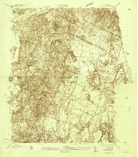
1935 Map of Pocasset
USGS Topo · Published 1935About this map
Camp Edwards and the adjacent Otis Field dominate the southeastern portion of this landscape, reflecting the military expansion on the Upper Cape during the mid-1930s. The coastline along Buzzards Bay is deeply indented by complex harbors and inlets, including Phinneys Harbor and Cataumet Harbor. Inland, the terrain is characterized by numerous kettle ponds and glacial depressions, such as Snake Pond and Peters Pond, interspersed with industrial and agricultural features like the Deep Bottom Bog. Transportation networks are well-defined by the NY NH and H RR, which serves coastal settlements at Pocasset Sta. The recent completion of the Bourne Bridge over the Cape Cod Canal at the north end of the sheet signals a transition in regional connectivity during this era of public works improvements.
Find a feature on this map
87 named features on this map. Tap any name to fly to it.
Don’t see what you’re looking for? This feature index may not catch every label — zoom into the map to look around manually.
Map Details
Editions of this 1935 Pocasset Map
This is the sole edition of this map. No revisions or reprints were ever made.
Other maps of this area

1886 · Falmouth
USGS Topo · 1:62,500

1886 · Plymouth
USGS Topo · 1:62,500

1888 · Barnstable
USGS Topo · 1:62,500

1888 · Falmouth
USGS Topo · 1:62,500

1889 · Plymouth
USGS Topo · 1:62,500

1893 · Barnstable
USGS Topo · 1:62,500

1893 · Falmouth
USGS Topo · 1:62,500

1894 · Plymouth
USGS Topo · 1:62,500

1915 · Falmouth
USGS Topo · 1:62,500

1920 · Falmouth
USGS Topo · 1:62,500