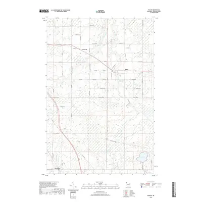
2018 Map of Poplar
USGS Topo · Published 2018About this map
Poplar and Wentworth anchor the northern landscape of Douglas County, where the terrain is defined by the drainage basins of the Middle River and Poplar River. The 2018 survey shows a rural infrastructure heavily influenced by the Tri-Co Corridor and a grid of township roads with family-named landmarks like Moonshine Rd and Barsness Rd. Near the southern edge, the settlement of Hawthorne sits adjacent to the Parkview Cem, while the interior remains a mosaic of wetlands and small water bodies including Steele Lake and Twin Lakes. The presence of Gravel Pit Rd and the E South Shore Grade hints at the industrial and rail history that shaped this portion of northern Wisconsin, providing a clear view of the modern road network superimposed over the traditional settlement patterns of the region.
Find a feature on this map
40 named features on this map. Tap any name to fly to it.
Don’t see what you’re looking for? This feature index may not catch every label — zoom into the map to look around manually.
Map Details
Editions of this 2018 Poplar Map
This is the sole edition of this map. No revisions or reprints were ever made.
Other maps of this area

1945 · Highland
USGS Topo · 1:48,000

1945 · Solon Springs
USGS Topo · 1:48,000

1947 · Brule
USGS Topo · 1:48,000

1949 · Solon Springs
USGS Topo · 1:48,000

1949 · Poplar
USGS Topo · 1:48,000

1949 · Highland
USGS Topo · 1:48,000

1953 · Ashland
USGS Topo · 1:250,000

1954 · Lake Nebagamon
USGS Topo · 1:24,000

1954 · Poplar NE
USGS Topo · 1:24,000
1954 · South Range
USGS Topo · 1:24,000