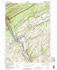
1992 Map of Portland
USGS Topo · Published 1995About this map
Kittatinny Mountain dominates the northwestern landscape, where the Appalachian Trail follows the ridgeline through the Worthington State Forest. The geography is defined by the deep cut of the Delaware River, which separates Pennsylvania and New Jersey at the iconic The Gap. This 1992 photo-inspection, based on earlier Army Map Service work, illustrates the transition from the river-bottom industrial sites like the powerplant and its conveyors near Portland to the agricultural and recreational lands of Knowlton and Blairstown.
Find a feature on this map
66 named features on this map. Tap any name to fly to it.
Don’t see what you’re looking for? This feature index may not catch every label — zoom into the map to look around manually.
Map Details
Editions of this 1992 Portland Map
This is the sole edition of this map. No revisions or reprints were ever made.
Other maps of this area

1888 · Hackettstown
USGS Topo · 1:62,500

1891 · Wallpack
USGS Topo · 1:62,500

1891 · Delaware Water Gap
USGS Topo · 1:62,500

1893 · Delaware Water Gap
USGS Topo · 1:62,500

1893 · Wallpack
USGS Topo · 1:62,500

1894 · Hackettstown
USGS Topo · 1:62,500

1898 · Hackettstown
USGS Topo · 1:62,500

1900 · Raritan
USGS Topo · 1:125,000

1905 · Raritan
USGS Topo · 1:125,000

1905 · Hackettstown
USGS Topo · 1:62,500