2023 Map of Post Lake
USGS Topo · Published 2023About this map
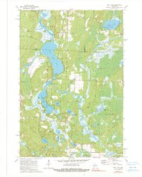
Wolf River serves as the central artery for this lake-heavy corridor of northern Wisconsin, connecting the massive basins of Upper Post Lake and Lower Post Lake. This landscape is defined by its post-glacial hydrology, where water travels through complex channels like Swamp Creek and Pollock Creek into smaller, isolated basins such as Wamin Lake and Bishop Lake. The settlement of Post Lake sits at the narrow constriction between the two primary lake bodies, while Mole Lake occupies the northeastern corner of the map, near the boundary where Oneida, Forest, and Langlade counties meet.
Find a feature on this map
71 named features on this map. Tap any name to fly to it.
Don’t see what you’re looking for? This feature index may not catch every label — zoom into the map to look around manually.
Map Details
Editions of this 2023 Post Lake Map
This is the sole edition of this map. No revisions or reprints were ever made.