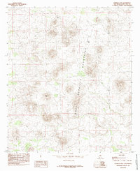
1985 Map of Potrillo Peak
USGS Topo · Published 1985About this map
The volcanic landscape of the West Potrillo Mountains dominates this mid-1980s topographical study in Doña Ana County. At its heart lies the prominent Potrillo Peak, surrounded by a complex system of cinder cones and desert basins. In this arid environment, the presence of various stock-watering features like Jays Tank, Bills Tank, and Hegens Tank indicates the land's utility for ranching and livestock management despite the challenging terrain. Farther south, Barbaras Tank serves as another localized marker in the high desert. The map's contour lines illustrate the stark elevation changes typical of this southwestern New Mexico range, capturing the transition from the desert floor to the heights of individual peaks before any significant modern development altered these remote volcanic fields.
Find a feature on this map
6 named features on this map. Tap any name to fly to it.
Don’t see what you’re looking for? This feature index may not catch every label — zoom into the map to look around manually.
Map Details
Editions of this 1985 Potrillo Peak Map
This is the sole edition of this map. No revisions or reprints were ever made.
Other maps of this area

1917 · Camel Mountain
USGS Topo · 1:62,500

1917 · Mt. Riley
USGS Topo · 1:62,500

1918 · Mt. Riley
USGS Topo · 1:62,500

1929 · Mt. Riley
USGS Topo · 1:62,500

1941 · Aden
USGS Topo · 1:62,500

1943 · Aden
USGS Topo · 1:62,500

1951 · Mt. Riley
USGS Topo · 1:62,500

1953 · El Paso
USGS Topo · 1:250,000

1955 · Las Cruces
USGS Topo · 1:250,000

1958 · Las Cruces
USGS Topo · 1:250,000