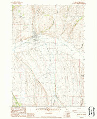
1988 Map of Prairie City
USGS Topo · Published 1988About this map
Prairie City sits at the confluence of Dixie Creek and the John Day River, serving as a central hub in this high-altitude landscape. The valley floor bears the distinct scars of industrial activity, most notably the extensive Dredge Tailings and Gravel Pits that follow the river’s path, indicating a history of mineral extraction. Irrigation and water management systems are essential to the area's agricultural operations, evidenced by the Flume Ditch, several Flumes, and various Stock Ponds scattered across the terrain.
Find a feature on this map
33 named features on this map. Tap any name to fly to it.
Don’t see what you’re looking for? This feature index may not catch every label — zoom into the map to look around manually.
Map Details
Editions of this 1988 Prairie City Map
This is the sole edition of this map. No revisions or reprints were ever made.
Other maps of this area

1940 · John Day
USGS Topo · 1:62,500

1943 · John Day
USGS Topo · 1:62,500

1949 · Susanville
USGS Topo · 1:62,500

1951 · Susanville
USGS Topo · 1:62,500

1951 · Bates
USGS Topo · 1:62,500

1955 · Canyon City
USGS Topo · 1:250,000

1959 · Canyon City
USGS Topo · 1:250,000

1959 · Prairie City
USGS Topo · 1:62,500
1972 · Castle Creek
USGS Topo · 1:24,000
1972 · Pine Creek Mtn
USGS Topo · 1:24,000