
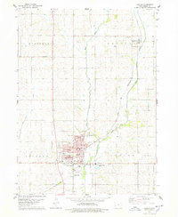
1978 Map of Prairie Rose Lake
USGS Topo · Published 1978About this map
Prairie Rose State Park serves as the central focal point of this western Iowa landscape, established around the waters of Prairie Rose Lake. This 1970s survey captures a transition in the rural environment, where public recreation infrastructure like the Campground, Boat Ramps, and a designated Picnic Area sit alongside traditional agricultural sections. The map reveals the hydrology of Shelby and Pottawattamie counties, defined by the winding paths of the West Nishnabotna River, Walnut Creek, and Indian Creek. Community life is anchored by landmarks such as Monroe Ch and a local Townhall, while the small settlement at Christensen provides a specific point of reference for local historians. The detailed topography illustrates the elevation changes near the Spillway Elev 1225, showing how the land was managed for both conservation and community utility in the late twentieth century.
Find a feature on this map
22 named features on this map. Tap any name to fly to it.
Don’t see what you’re looking for? This feature index may not catch every label — zoom into the map to look around manually.
Map Details
Editions of this 1978 Prairie Rose Lake Map
This is the sole edition of this map. No revisions or reprints were ever made.
Other maps of this area

1954 · Omaha
USGS Topo · 1:250,000

1957 · Omaha
USGS Topo · 1:250,000

1958 · Omaha
USGS Topo · 1:250,000

1963 · Avoca
USGS Topo · 1:24,000

1971 · Walnut
USGS Topo · 1:24,000

1971 · Atlantic
USGS Topo · 1:24,000

1978 · Elk Horn
USGS Topo · 1:24,000

1978 · Kimballton
USGS Topo · 1:24,000

1978 · Corley
USGS Topo · 1:24,000
1978 · Harlan
USGS Topo · 1:24,000