2022 Map of Preston
USGS Topo · Published 2022About this map
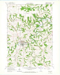
Preston serves as the focal point of this Fillmore County survey, centered at the confluence of the South Branch Root River and Willow Cr. As the county seat, the village is anchored by the Fillmore County Courthouse and surrounded by a dense network of local landmarks, including Saint Columbanus Cem, Crown Hill Cem, and Greenwood Cem. The landscape is defined by the sharp meanders of the S Br Root River and its tributaries, such as Watson Cr and Camp Cr, which carve through the region's characteristic terrain. To the north and west, the smaller settlements of Isinours and Fountain are connected by the Root River State Trl, highlighting a modern transition from rail corridors to recreational pathways. This transformation is further evidenced by the Harmony-Preston Valley State Trl, which follows the river valleys south toward rural intersections like the Richland Prairie Presbyterian Cem.
Find a feature on this map
76 named features on this map. Tap any name to fly to it.
Don’t see what you’re looking for? This feature index may not catch every label — zoom into the map to look around manually.
Map Details
Editions of this 2022 Preston Map
This is the sole edition of this map. No revisions or reprints were ever made.