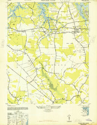
1948 Map of Princess Anne
USGS Topo · Published 1948About this map
Princess Anne serves as the focal point for this Tidewater landscape during the late 1940s, a period of transition for this coastal Virginia region. The map reveals a mosaic of established agricultural settlements and emerging aviation infrastructure, most notably the Oceana Airport and Camp Ashby. The transportation network is defined by the Norfolk Southern railroad and the Currituck Branch, which link communities like Lynnhaven and Oceana to the broader Atlantic coast.
Find a feature on this map
74 named features on this map. Tap any name to fly to it.
Don’t see what you’re looking for? This feature index may not catch every label — zoom into the map to look around manually.
Map Details
Editions of this 1948 Princess Anne Map
This is the sole edition of this map. No revisions or reprints were ever made.
Other maps of this area

1893 · Virginia Beach
USGS Topo · 1:125,000

1907 · Norfolk
USGS Topo · 1:125,000

1916 · Back Bay
USGS Topo · 1:62,500

1918 · Cape Henry
USGS Topo · 1:62,500

1919 · Cape Henry
USGS Topo · 1:62,500

1939 · Moyock
USGS Topo · 1:62,500

1943 · Back Bay
USGS Topo · 1:62,500

1946 · Moyock
USGS Topo · 1:62,500

1946 · Eastville
USGS Topo · 1:250,000

1946 · Currituck Sound
USGS Topo · 1:250,000