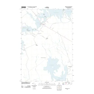
2011 Map of Princeton
USGS Topo · Published 2011About this map
Pocomoonshine Lake and the complex waters of Lewy Lake anchor this map of eastern Washington County, Maine. The town of Princeton sits at a critical junction where the lake systems meet Grand Falls Flowage, characterized by a shoreline of named points such as Second Point, Greenland Point, and Tierney Point. This area reflects a landscape where water and timber are central, evidenced by the University of Maine Forestry Camp near Long Lake and multiple campgrounds like Big Lake Campground. The mapping details the local infrastructure supporting these small communities, from the Princeton Post Office and Princeton Municipal Airport to the rural roads connecting West Princeton and South Princeton. Notable landmarks for local researchers include the Princeton Cemetery and Lakeview Cemetery, along with family-named locations like Lamb Place on the northern edge of the flowage.
Find a feature on this map
63 named features on this map. Tap any name to fly to it.
Don’t see what you’re looking for? This feature index may not catch every label — zoom into the map to look around manually.
Map Details
Editions of this 2011 Princeton Map
This is the sole edition of this map. No revisions or reprints were ever made.
Other maps of this area

1929 · Calais
USGS Topo · 1:48,000

1932 · Calais
USGS Topo · 1:62,500

1940 · Waite
USGS Topo · 1:62,500

1940 · Kellyland
USGS Topo · 1:62,500

1941 · Big Lake
USGS Topo · 1:62,500

1942 · Kellyland
USGS Topo · 1:62,500

1942 · Waite
USGS Topo · 1:62,500

1943 · Big Lake
USGS Topo · 1:62,500

1952 · Big Lake
USGS Topo · 1:50,000

1957 · Fredericton
USGS Topo · 1:250,000