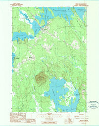
1990 Map of Princeton
USGS Topo · Published 1990About this map
The town of Princeton sits at the heart of this Washington County landscape, positioned between the waters of Lewy Lake and the Grand Falls Flowage. This 1990 survey captures the unique geography of the St. Croix Valley region, where the Indian Twp Indian Reservation borders the northern reaches of the settlement. The map documents the scattered residential patterns of West Princeton and South Princeton, along with local landmarks such as the Princeton Cem and the Municipal Airport.
Find a feature on this map
45 named features on this map. Tap any name to fly to it.
Don’t see what you’re looking for? This feature index may not catch every label — zoom into the map to look around manually.
Map Details
Editions of this 1990 Princeton Map
This is the sole edition of this map. No revisions or reprints were ever made.
Other maps of this area

1929 · Calais
USGS Topo · 1:48,000

1932 · Calais
USGS Topo · 1:62,500

1940 · Waite
USGS Topo · 1:62,500

1940 · Kellyland
USGS Topo · 1:62,500

1941 · Big Lake
USGS Topo · 1:62,500

1942 · Kellyland
USGS Topo · 1:62,500

1942 · Waite
USGS Topo · 1:62,500

1943 · Big Lake
USGS Topo · 1:62,500

1952 · Big Lake
USGS Topo · 1:50,000

1957 · Fredericton
USGS Topo · 1:250,000