1945 Map of Provencal
USGS Topo · Published 1945About this map
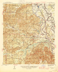
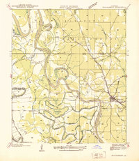
Cane River Lake and the serpentine curves of the Red River dominate the eastern landscape of this 1940s survey, illustrating a classic Louisiana delta environment where water dictates the patterns of settlement. The Texas and Pacific RR serves as a primary transit spine, connecting the communities of Provencal, Cypress, and Flora. Evidence of the region's timber and agricultural heritage is visible through the Logging RR spurs and the numerous family-named landmarks and country churches, such as Hickory Grove Ch and St Charles Ch, which anchor the rural neighborhoods.
Find a feature on this map
116 named features on this map. Tap any name to fly to it.
Don’t see what you’re looking for? This feature index may not catch every label — zoom into the map to look around manually.
Map Details
Editions of this 1945 Provencal Map
This is the sole edition of this map. No revisions or reprints were ever made.
Other maps of this area

1935 · Hagewood
USGS Topo · 1:31,680

1937 · Bermuda
USGS Topo · 1:31,680

1937 · Campti SE
USGS Topo · 1:31,680

1937 · Chopin NW
USGS Topo · 1:31,680

1937 · Bellwood
USGS Topo · 1:31,680
1937 · Montgomery
USGS Topo · 1:62,500

1937 · Campti SW
USGS Topo · 1:31,680

1937 · Cloutierville
USGS Topo · 1:31,680

1937 · Cypress
USGS Topo · 1:31,680

1938 · Allen
USGS Topo · 1:31,680