Old Maps of Louisiana
Explore 7,110 old maps of Louisiana, spanning from 1891 to today. These high-resolution historic maps reveal how streets, neighborhoods, landmarks, and natural features evolved over time — perfect for genealogy, metal detecting, research, and local history exploration.
What you can do with these maps:
- See how Louisiana changed over time: Compare historical maps to modern-day views to trace roads, homesites, rail lines & more.
- View detailed metadata: Each map includes creators, publishers, year, scale, and archive source.
- Overlay maps with satellite & LiDAR: Visualize the past alongside modern tools to explore terrain & human change.
- Trusted historical sources: Maps sourced from the USGS, Library of Congress, and other archives.
- Access maps your way: View online, download high-res files, or order prints for personal or research use.
Start exploring old maps of Louisiana to uncover forgotten places, hidden landmarks, and the deep history beneath your feet.
Louisiana maps
(7,110)- 1891 Map of Hahnville
 1891 Hahnville1891 Print · USGSSt. Charles Parish was a hub of river and rail commerce in the late nineteenth century, where new tracks began to bridge the gap between New Orleans and the southern bayous. Researchers can trace historic riverfront tracts at Hahnville and Luling or locate family-named landings such as Pecan Grove and Loquer.5 unique versions available
 - 1891 Map of Spanish Fort
 1891 Spanish Fort1891 Print · USGSThe New Orleans lakefront in the early 1890s was a landscape of emerging rail hubs and shoreline outposts. Trace the early footprints of Milneburg, Spanish Fort, and the lighthouse stations along Lake Pontchartrain during this pivotal era of coastal growth.4 unique versions available
 - 1891 Map of Pointe a La Hache
 1891 Pointe a La Hache1891 Print · USGSCoastal Plaquemines Parish and the Mississippi River delta appear here in the early 1890s, revealing a landscape of narrow riverfront plantations and rail-connected settlements. Researchers can trace the path of the New Orleans Ft Jackson and Grand Isl Railroad through historic sites like Pt A La Hache, Myrtle Grove, and Empire Mills.
 - 1891 Map of New Orleans
 1891 New Orleans1891 Print · USGSGreater New Orleans and the surrounding bayous are captured in the late Victorian era as the city's rail and canal networks expanded. Researchers can trace the development of riverfront communities like Gretna and Algiers or locate now-obscure landings such as Jesuit Bend and Amesville.5 unique versions available
 - 1892 Map of Barataria
 1892 Barataria1892 Print · USGSCoastal Jefferson and Plaquemines parishes appear in the late nineteenth century as a sprawling network of marshlands and navigable bayous. Researchers can trace the early rail influence of the N. O. F. J. & G. I. R. R. and locate family landmarks like John the Fool Island and the settlement of Barataria.3 unique versions available
 - 1892 Map of Cheniere Caminada
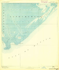 1892 Cheniere Caminada1892 Print · USGSLouisiana's gulf coast appears in the early 1890s, shortly before a catastrophic hurricane forever changed the local landscape. Genealogists can trace the footprint of Cheniere Caminada and the early layout of Grand Isle near Caminada Pass.4 unique versions available
 - 1892 Map of Lac Des Allemands
 1892 Lac Des Allemands1892 Print · USGSCoastal Louisiana at the end of the nineteenth century is defined by its massive marsh basins and early rail corridors. Researchers can trace the original routes of the Southern Pacific Railroad and locate specific sites like the Indian Mound or Raceland Station.4 unique versions available
 - 1892 Map of Chef Menteur
 1892 Chef Menteur1892 Print · USGSThe marshlands of eastern Orleans Parish appear here in the 1890s as a strategic coastal corridor of railroads and water passages. Researchers can trace the early rail stops at Micheaud and Lee, or locate the historic site of Ft Macomb near the Chef Menteur crossing.5 unique versions available
 - 1892 Map of Mount Airy
 1892 Mount Airy1892 Print · USGSThe lower Mississippi River corridor is captured here in the early 1890s, showcasing the traditional long-lot plantations and burgeoning rail towns. Researchers can trace the early footprints of Edgard and Mt Airy or locate family-named landmarks like Pauline and Johnson along the river's edge.4 unique versions available
 - 1892 Map of Quarantine
 1892 Quarantine1892 Print · USGSThe lower Mississippi Delta in the 1890s appears as a fragile network of river settlements and sprawling bayous. Genealogists and historians can trace family locations at Guyot Settlement, the Quarantine station, and Buras Settlement.5 unique versions available
 - 1892 Map of Gibson
 1892 Gibson1892 Print · USGSCoastal Louisiana in the early 1890s is captured here as a landscape of bayous and new rail lines. Genealogists and historians can trace family land along Bayou Black or locate old railway stops at Gibson, Chacahoula, and Schriever.4 unique versions available
 - 1892 Map of Bonnet Carre
 1892 Bonnet Carre1892 Print · USGSThe Louisiana delta in the 1890s reveals a landscape of riverfront settlements and strategic rail lines at the edge of the lake. Trace the path of the Bonnet Carre Crevasse or locate old landings at Frenier, Lucy, and La Branche.3 unique versions available
 - 1892 Map of Cut-Off
 1892 Cut-Off1892 Print · USGSCoastal Louisiana in the 1890s is defined by its reliance on water for transit and trade. Trace the early settlement patterns of Gheens, Harang, and Cut Off along the historic Bayou Lafourche and its connecting canals.4 unique versions available
 - 1892 Map of Houma
 1892 Houma1892 Print · USGSCoastal Louisiana in the 1890s shows a landscape of waterborne commerce and rising rail lines. Genealogists and historians can trace old homesteads along Bayou Lafourche or study the early street grid of Houma and the path of the Southern Pacific Railroad.4 unique versions available
 - 1892 Map of Creole
 1892 Creole1892 Print · USGSCoastal Lafourche and Jefferson parishes appear in the early 1890s as a complex of tidal wetlands and prairies. Genealogists and historians can trace the original watercourses of Bayou Lafourche, Little Lake, and the remote Shrimp Ids.4 unique versions available
 - 1892 Map of Donaldsonville
 1892 Donaldsonville1892 Print · USGSLouisiana river life in the early 1890s centered on the great meanders and landings of the river parishes. Genealogists and historians can trace the early footprints of Donaldsonville, locate the Indian Mounds, and see the impact of the Nita Crevasse on the shoreline.12 unique versions available
 - 1892 Map of St. Bernard
 1892 St. Bernard1892 Print · USGSCoastal Louisiana in the early 1890s is captured here as a landscape of river-bend settlements and expanding rail lines. Genealogists and historians can trace family land and depots at Poydras, St Bernard, and the New Orleans and Gulf Railroad stops.4 unique versions available
 - 1892 Map of Thibodaux, 1898 Print
 1892 Thibodaux1898 Print · USGSCajun country at the end of the nineteenth century is defined here by the winding course of Bayou Lafourche and its riverside communities. Genealogists and local historians can trace the early footprints of Thibodeaux and Labadieville alongside rail lines like the Southern Pacific Railroad.3 unique versions available
 - 1892 Map of Pointe a La Hache, 1898 Print
 1892 Pointe a La Hache1898 Print · USGSThe lower Mississippi delta in the 1890s reveals a ribbon of riverfront settlements and competing rail lines. Genealogists and historians can trace family-named sites like Savoie and Nero or locate the Empire Mills (Martin) near Pt. A La Hache.
 - 1893 Map of Cat Island
 1893 Cat Island1893 Print · USGSThe Louisiana-Mississippi coastal border appears here in the late nineteenth century, charting the vital islands and channels of the Gulf. Researchers can trace the early maritime landscape of Cat Island, the position of Cat Island Light, and the reaches of Isle A Pitre.4 unique versions available
 - 1893 Map of Rigolets
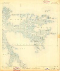
 1893 Rigolets1893 Print · USGSCoastal Louisiana and Mississippi meet at the turn of the century along a labyrinth of marshlands and railroad trestles. Researchers can trace the early path of the Louisville and Nashville Railroad past Ft. Pike and through the Little Lake region.5 unique versions available
 - 1893 Map of East Delta
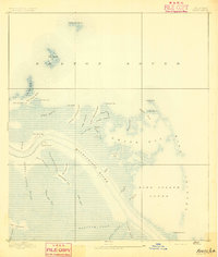
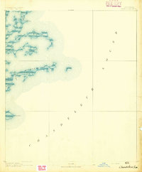
 1893 East Delta1893 Print · USGSThe tip of the Mississippi River delta comes alive in the 1890s, where river pilots and maritime outposts guarded the gateway to the Gulf. Genealogists and historians can trace the foundations of Port Eads and Balize, or locate the Old Spanish Magazine and the early South Pass Light.6 unique versions available
 - 1893 Map of La Fortuna
 1893 La Fortuna1893 Print · USGSSt. Bernard Parish’s coastal marshes and sounds are documented here in the late nineteenth century before major modern shoreline changes. Trace the original hydrology of the bayous including Bayou Terre Aux Boeufs, Lake La Fortuna, and Eloi Bay.3 unique versions available
 - 1893 Map of Forts
 1893 Forts1893 Print · USGSThe strategic lower Mississippi delta comes into focus in the 1890s, when river defense and delta navigation were paramount. Historians can trace the exact footprints of Fort Jackson and Fort St. Phillip or locate old waterways like Lucas Canal.4 unique versions available
 - 1893 Map of Chandeleur
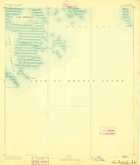
 1893 Chandeleur1893 Print · USGSThe Louisiana barrier islands and outer marshes are captured in the late 1890s, revealing a coastline since reshaped by nature. Trace historical maritime markers like Keelboat Pass, Mitchell Key, and the remote Barrel Key.3 unique versions available
Showing maps 1-25 of 7,110
Top cities of Louisiana
- New Orleans historical maps
- Baton Rouge historical maps
- Shreveport historical maps
- Metairie historical maps
- Lafayette historical maps
- Saint George historical maps
See more
Top parishes of Louisiana
- Jefferson Parish historical maps
- Orleans Parish historical maps
- Caddo Parish historical maps
- St. Tammany Parish historical maps
- Lafayette Parish historical maps
- Calcasieu Parish historical maps
See more
Frequently asked questions
- What are the different types of historical maps available for Louisiana?
- What is the oldest map of Louisiana?
- Where can I purchase historical maps of Louisiana for my home or office?
- Where can I download high-res historical maps of Louisiana?
- Are there historical topographic maps available for Louisiana?
- Is there historical aerial imagery available for Louisiana?
- Where are historical maps of Louisiana sourced from?