1950s Maps of Louisiana
Explore 496 historic maps of Louisiana from the 1950s. These maps offer a rare glimpse into what life looked like during the 1950s — showing old roads, neighborhoods, homes, and landmarks that have changed or disappeared over time.
Whether you're researching your family's past, planning a metal detecting trip, or studying how Louisiana's landscape evolved across the 1950s, these high-resolution maps are a powerful tool for exploring the history of this region.
- Focus on a specific era: All maps on this page are from the 1950s, giving you a focused view of this time period.
- See what’s changed: Compare century-old streets, trails, and buildings to today's modern landscape using overlays and satellite layers.
- Research with precision: Use these maps for genealogy, historical research, land use analysis, or educational projects.
- View, download, or print: Maps are fully viewable online in high resolution, and can be downloaded or printed for your own records.
Start exploring Louisiana's history through authentic maps from the 1950s. This is your window into the past.
Louisiana maps
(496)- 1950 Map of Doyle
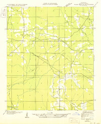
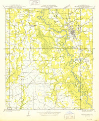
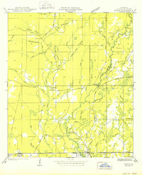 1950 Doyle1950 Print · USGSLivingston Parish at the start of the 1940s is shown here as a landscape of rail-side towns and rural creek-bottom settlements. Genealogists can locate family burial sites like Stafford Cem and Lard Cem or trace the early path of the Illinois Central Railroad through Holden.
 - 1950 Map of Plain Dealing SW
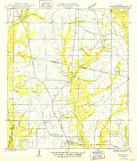
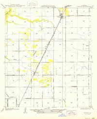
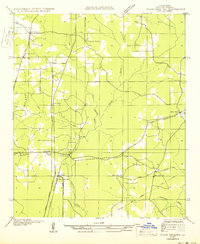 1950 Plain Dealing SW1950 Print · USGSBossier Parish at mid-century shows a landscape shaped by rail transport and rural community hubs like Collinsburg and Rocky Mount. Genealogists and historians can locate family-named sites such as Booker Chapel, New Light Sch, and the St Louis Southwestern RR corridor.
 - 1950 Map of Plain Dealing NE
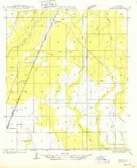
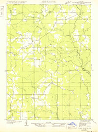 1950 Plain Dealing NE1950 Print · USGSUpper Bossier Parish was a landscape of timber and oil during the mid-century, defined by small settlements and resource extraction. Genealogists and researchers can trace local landmarks like Elizabeth Sch, the Goodwin Sawmill, and the Carterville Oil Field.
 - 1950 Map of Derniere
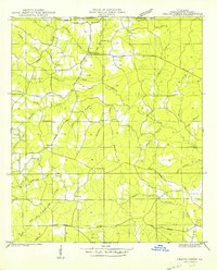
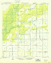
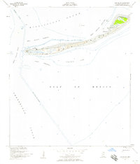
 1950 Derniere1950 Print · USGSThe Terrebonne Parish coast and barrier islands are captured at mid-century before significant land loss altered the shoreline. Researchers can trace the early footprints of coastal settlements like Villette and Pelican or the original reach of Whisky Island.
 - 1950 Map of Golden Meadow Farms
 1950 Golden Meadow Farms1950 Print · USGSLafourche Parish during the mid-century period shows the intensive drainage efforts used to transform the coastal marsh. Genealogists and historians can trace the early layout of Golden Meadow Farms and the paths of the Raphael Canal and Yankee Canal.
 - 1950 Map of Kentwood
 1950 Kentwood1950 Print · USGSKentwood and Tangipahoa thrive along the Illinois Central rail corridor during the mid-century, marking a period of established rural settlement along the Mississippi state line. Researchers can locate numerous family burial sites and churches, including the Camp Moore Confederate Cem, Barnes Cem, and Bethel Ch.
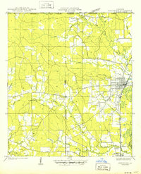
 - 1950 Map of Plain Dealing SE
 1950 Plain Dealing SE1950 Print · USGSBossier Parish during the mid-century transition preserves a detailed look at rural life centered around the Magnolia Lumber RR. Genealogists and local historians can locate several family churches and schools, such as Galilee Sch, Aimwell Ch, and Springhill Ch.
 - 1950 Map of Greensburg
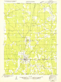
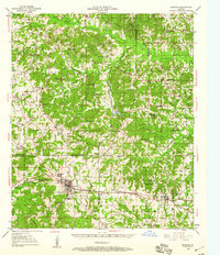
 1950 Greensburg1950 Print · USGSMid-century St. Helena Parish comes into focus in this detailed topographic record of the area surrounding the parish seat. Local historians can trace the precise locations of rural community centers like the St Helena Training Sch, Crossroads Ch, and Hutchinson Cem.
 - 1950 Map of Folsom
 1950 Folsom1950 Print · USGSThe northern piney woods of St. Tammany Parish are captured here at mid-century, centered on the crossroads of Folsom. Local historians can trace family roots at Owens Cem and Pierre Cem or locate early schools like the Folsom Rosenwald Sch.
 - 1950 Map of Foley
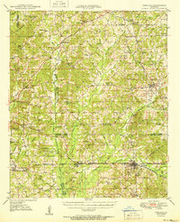
 1950 Foley1950 Print · USGSAllen Parish was a hub of timber and rail activity in the mid-twentieth century. Genealogists and historians can trace the development of Foley and Canton or locate local landmarks like Pine Sch and the extensive Old Logging Railroad Grade.
 - 1950 Map of Crains Creek
 1950 Crains Creek1950 Print · USGSWashington Parish at the midpoint of the century is a landscape of rural family homesteads and timberlands along the Mississippi border. Researchers can trace ancestral roots through numerous burial sites like Schillings Cem and local schoolhouses like Crains Creek Sch.
 - 1950 Map of Fenton
 1950 Fenton1950 Print · USGSJefferson Davis Parish in the mid-twentieth century is shown here as a landscape of rail-side settlements and winding bayous. Genealogists can trace family footprints through rural sites like Rose Hill School, Woodlawn, and the Woodlawn Cem.
 - 1950 Map of Plain Dealing NW
 1950 Plain Dealing NW1950 Print · USGSBossier Parish at the Arkansas border is captured here during the mid-twentieth century, centered on the rail-to-road transition. Genealogists can trace family roots at Oak Hill Cemetery or locate landmarks like Bolinger and Macedonia Sch.
 - 1950 Map of Hecker
 1950 Hecker1950 Print · USGSSouthwestern Louisiana's wetlands and early agricultural infrastructure are visible here in the years following the mid-1930s field surveys. Trace the Old Logging Railroad Grade and the engineering of the Louisiana Irrigation Canal near Hecker.
 - 1950 Map of Jonesboro
 1950 Jonesboro1950 Print · USGSJackson and Winn Parish communities are captured here in the mid-twentieth century as the timber and rail economy flourished. Researchers can trace the Chicago Rock Island and Pacific rail line between Jonesboro and Dodson, locating rural landmarks like Mt Hebron Sch and Zion Hill Ch.2 unique versions available
 - 1950 Map of Franklinton
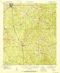
 1950 Franklinton1950 Print · USGSMid-century Washington Parish comes to life through this detailed survey of the area surrounding the Bogue Chitto River. Researchers can trace family history at sites like Bickham Cem, Sunlight Ch-, and the Bellevue Sch during a time when small communities like Jenkins were still prominently mapped.
 - 1950 Map of Gibsland
 1950 Gibsland1950 Print · USGSMid-century Bienville Parish is revealed here as a landscape of crossroads communities and emerging energy fields just after the war. Researchers can trace family roots through numerous rural landmarks like Mt Lebanon, Germantown Ch, and the Mayflower Sch.
 - 1950 Map of Haaswood
 1950 Haaswood1950 Print · USGSThe Pearl River bottomlands at the turn of the 1950s showcase a maze of islands and bayous along the Louisiana and Mississippi state line. Researchers can locate community anchors like Indian Village Sch, Hartsell Ch, and the riverside settlement of Logtown.
 - 1950 Map of Dry Creek, 1952 Print
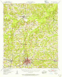
 1950 Dry Creek1952 Print · USGSLouisiana's Beauregard Parish was a landscape of small crossroads and creek-side settlements in the early fifties. Researchers can trace rural lineages through sites like Shiloh Cem, the town of Dry Creek, and local landmarks like Midway Ch.
 - 1950 Map of Ruston, 1956 Print
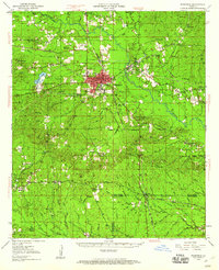
 1950 Ruston1956 Print · USGSLincoln Parish at mid-century centers on the expansion of Ruston and the campus of Grambling College during a period of steady growth. Researchers can trace rural lineages through numerous country landmarks like New Prospect Ch, Macedonia Cem, and Culbertson Sch.2 unique versions available
 - 1950 Map of Dog Keys Pass, 1958 Print
 1950 Dog Keys Pass1958 Print · USGSThe Mississippi barrier islands and their deep-water channels are captured here at mid-century, documenting the coastal boundary between Harrison and Jackson counties. Marine researchers and historians can trace the 1950s shorelines of Ship Island and Horn Island near the vital Dog Keys Pass.3 unique versions available
 - 1950 Map of Ship Island, 1958 Print
 1950 Ship Island1958 Print · USGSCoastal Mississippi in the 1950s is defined here by the thin, strategic arc of Ship Island before modern storms reshaped its shores. Trace the maritime history of the sound through landmarks like Old Fort Massachusetts and the Ship Island Lighthouse.3 unique versions available
 - 1950 Map of Breton Islands, 1958 Print
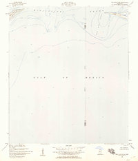
 1950 Breton Islands1958 Print · USGSThe Louisiana coast in the early fifties is seen through this survey of Breton Island, an area dedicated to the Breton National Wildlife Refuge. Trace navigational aids like the Breton Island Light and maritime landmarks near North Point.
 - 1950 Map of Arcadia, 1960 Print
 1950 Arcadia1960 Print · USGSNorthern Louisiana during the mid-century was a landscape of dense rail corridors and rural schoolhouses. Genealogists can trace the ILLINOIS CENTRAL line through ARCADIA and find remote landmarks like Macedonia Ch and Point Pleasant Cem.4 unique versions available
 - 1950 Map of Winnfield, 1960 Print
 1950 Winnfield1960 Print · USGSNorth-central Louisiana centers on the timber and rail hub of Winnfield in the years following World War II. Genealogists and local historians can trace rural roots through landmarks like Sardis Ch, Crockett Cem, and the old rail siding at Carla.3 unique versions available
Showing maps 1-25 of 496
Top cities of Louisiana
- New Orleans historical maps
- Baton Rouge historical maps
- Shreveport historical maps
- Metairie historical maps
- Lafayette historical maps
- Saint George historical maps
See more
Top parishes of Louisiana
- Jefferson Parish historical maps
- Orleans Parish historical maps
- Caddo Parish historical maps
- St. Tammany Parish historical maps
- Lafayette Parish historical maps
- Calcasieu Parish historical maps
See more
Frequently asked questions
- What are the different types of historical maps available for Louisiana?
- What is the oldest map of Louisiana?
- Where can I purchase historical maps of Louisiana for my home or office?
- Where can I download high-res historical maps of Louisiana?
- Are there historical topographic maps available for Louisiana?
- Is there historical aerial imagery available for Louisiana?
- Where are historical maps of Louisiana sourced from?