1940s Maps of Louisiana
Explore 339 historic maps of Louisiana from the 1940s. These maps offer a rare glimpse into what life looked like during the 1940s — showing old roads, neighborhoods, homes, and landmarks that have changed or disappeared over time.
Whether you're researching your family's past, planning a metal detecting trip, or studying how Louisiana's landscape evolved across the 1940s, these high-resolution maps are a powerful tool for exploring the history of this region.
- Focus on a specific era: All maps on this page are from the 1940s, giving you a focused view of this time period.
- See what’s changed: Compare century-old streets, trails, and buildings to today's modern landscape using overlays and satellite layers.
- Research with precision: Use these maps for genealogy, historical research, land use analysis, or educational projects.
- View, download, or print: Maps are fully viewable online in high resolution, and can be downloaded or printed for your own records.
Start exploring Louisiana's history through authentic maps from the 1940s. This is your window into the past.
Louisiana maps
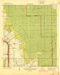
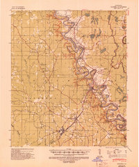
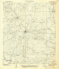
(339)- 1940 Map of Lagan
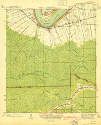 1940 Lagan1940 Print · USGSSt. James Parish at the cusp of the 1940s retains its deep-rooted plantation landscape along the river's edge. Genealogists and historians can trace family landholdings from Oak Alley Plantation to Bessie K and locate rural landmarks like St Lukes Ch and Chegby Sch.2 unique versions available
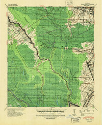
 - 1940 Map of Spring Creek
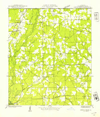 1940 Spring Creek1940 Print · USGSTangipahoa Parish at the start of the 1940s is a landscape of creek-side farms and rural crossroads. Trace family roots and local landmarks like German Cem, Midway Sch, and the Illinois Central Railroad corridor.
 - 1940 Map of Allemands
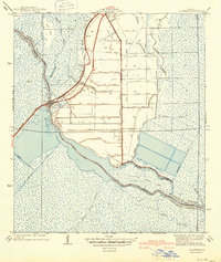 1940 Allemands1940 Print · USGSCoastal Louisiana marshlands and reclaimed swamps are frozen in time just before the mid-century, centered on the railroad crossing at Des Allemands Sta. Genealogists and historians can trace the grid of the Crawford Canal and locate the St. Charles Sch along the Southern Pacific tracks.2 unique versions available
 - 1940 Map of Belle Chasse
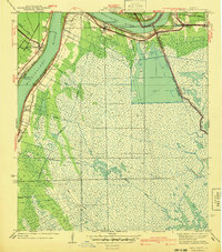 1940 Belle Chasse1940 Print · USGSCoastal Louisiana during the late 1930s is defined here by its intricate canal systems and riverside rail hubs. Trace the local economy through the Sea Train Terminal at Belle Chasse or the marshland paths near Tigers Ridge and Lake Lery.
 - 1940 Map of Lafourche
 1940 Lafourche1940 Print · USGSLouisiana's bayou country in the late 1930s is mapped here in detail, showcasing the agricultural and rail heart of the region. Researchers can trace historic family lands like Rienzi Plantation and find local landmarks such as Morningstar Ch and Thibodaux Junction.
 - 1940 Map of Madewood
 1940 Madewood1940 Print · USGSAssumption Parish at the end of the 1930s shows a landscape defined by the sugar economy and the wetlands. Genealogists and historians can trace family locations along Bayou Lafourche through old settlements like Madewood, Albemarle, and Aurelia.2 unique versions available
 - 1940 Map of Bertrandville
 1940 Bertrandville1940 Print · USGSCoastal Louisiana at the start of the 1940s reveals a world of riverfront settlements and canal-driven industry. Genealogists and historians can trace the foundations of Bertrandville, locate St Johns Ch, and find long-standing landmarks like Woodlawn Sch along the Mississippi River.
 - 1940 Map of Tickfaw
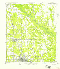 1940 Tickfaw1940 Print · USGSTangipahoa Parish at the start of the 1940s is shown here as a landscape of river-bottom woods and growing railroad towns. Researchers can trace the development of Hammond and SE LA COLLEGE, or locate family landmarks like Red Hill Sch and Colonial Cem.
 - 1940 Map of Monroe, 1942 Print
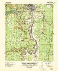 1940 Monroe1942 Print · USGSThe Ouachita River valley at the onset of the 1940s shows a landscape defined by its waterways and burgeoning river towns. Genealogists and historians can trace family roots through numerous country landmarks like Logtown Ch, Faulks Sch, and the La Training Institute for Boys.2 unique versions available
 - 1940 Map of Marksville, 1943 Print
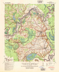 1940 Marksville1943 Print · USGSAvoyelles Parish life in the early 1940s is centered on the river-and-rail economy of the Red River valley. Genealogists and historians can trace family locations through numerous named churches and schools, such as Hickory Hill Sch, Vick, and the St Paul Ch & Cem.2 unique versions available
 - 1940 Map of Columbia, 1945 Print
 1940 Columbia1945 Print · USGSCaldwell Parish at the start of the 1940s shows a landscape defined by the winding Ouachita River and the regional lumber industry. Genealogists and historians can trace families near Old Mt Pleasant, locate Oak Grove Sch, and follow the old Louisiana Central Lumber Company rail lines.
 - 1940 Map of Grosse Tete, 1950 Print
 1940 Grosse Tete1950 Print · USGSThe Louisiana river parishes are shown just before the mid-century, defined by a complex network of bayous and sprawling plantation estates. Genealogists and historians can trace family-named sites like Shady Grove Plantation, United Reformers Ch & Sch, and the Texas and Pacific RR corridor.
 - 1940 Map of Roseland, 1954 Print
 1940 Roseland1954 Print · USGSTangipahoa Parish in the 1940s is seen here as a series of rail-side towns and rural crossroads along the Illinois Central Railroad. Genealogists and historians can trace early community hubs like Fluker, Arcola, and the Kelly Cem.
 - 1940 Map of Bayou Du Large, 1962 Print
 1940 Bayou Du Large1962 Print · USGSCoastal Terrebonne Parish appears here as it was surveyed just before the war, a landscape of intricate bayous and expansive lakes. Genealogists and researchers can trace local settlements and landmarks like Theriot, St Andrews Ch, and the remote Bourgs Camp.
 - 1940 Map of Arnaudville, 1964 Print
 1940 Arnaudville1964 Print · USGSThe Cajun heartland of the 1940s is detailed here as it manages its complex relationship with the Atchafalaya. Genealogists can trace family names through landmarks like Le Bourgeois Plantation, Magenta Plantation, and the St Elizabeth Ch & Sch.
 - 1941 Map of Bayou Du Large
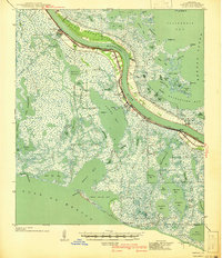
 1941 Bayou Du Large1941 Print · USGSCoastal Terrebonne Parish in the early 1940s is a landscape of expansive lakes and narrow bayou ridges. Genealogists and local historians can trace the community life of Theriot and locate landmarks like Johnson Ch, St Andrews Ch, and an ancient Indian Mound.
 - 1941 Map of Leesville
 1941 Leesville1941 Print · USGSVernon Parish at the start of the 1940s reveals a transition from a logging-dependent economy to a more established network of rural towns. Researchers can trace family roots at Bill Cem, locate the old Cooper Sch, or follow the path of the Kansas City Southern Railroad through Newllano.
 - 1941 Map of Cut-Off
 1941 Cut-Off1941 Print · USGSCoastal Lafourche Parish is captured here just before the mid-century, showing the reclaimed wetlands and bayou-side life. Genealogists can trace family settlements at Larose, Valentine, and Gheens, or locate sites like Sacred Heart Ch and Bourgeois Sch.2 unique versions available
 - 1941 Map of Lake Felicity
 1941 Lake Felicity1941 Print · USGSCoastal Louisiana at the end of the thirties reveals a landscape of marshland life centered on Bayou Lafourche. Researchers can trace family roots at Golden Meadow or locate rural landmarks like Cheramie Cem and Naquin Sch.
 - 1941 Map of Zwolle
 1941 Zwolle1941 Print · USGSSabine Parish in the early 1940s is captured here as a landscape of timber-driven rail lines and riverside crossings. Genealogists can trace the rural communities of the era through sites like Pattersons Ferry, Alliance Sch, and Sardis Cem.
 - 1941 Map of Black Bay
 1941 Black Bay1941 Print · USGSCoastal Plaquemines Parish and St. Bernard Parish are shown in detail at the end of the 1930s, when river life and marsh navigation defined the region. Researchers can locate riverfront settlements like City Price and Happy Jack or trace the waterways of Lake Coquille and Petain Lagoon.
 - 1941 Map of East Point
 1941 East Point1941 Print · USGSThe Red River Valley bottomlands are captured here in the late 1930s, showing a network of riverfront settlements and rural parish life. Researchers can trace family history through numerous landmarks like Elizabeth Church, Crichton School, and the St Marks Cemetery near the Bayou Toulon.
 - 1941 Map of Empire
 1941 Empire1941 Print · USGSPlaquemines Parish comes to life in this pre-war survey of the Mississippi River delta as it transitions into the Gulf. Genealogists and historians can trace the riverfront rail line through Port Sulphur and Buras, or locate landmarks like Pt Pleasant Cem and Swartze Sch.
 - 1941 Map of Honey Island
 1941 Honey Island1941 Print · USGSThe lower Pearl River basin at the start of the 1940s reveals a dense network of swamp bayous and rail sidings. Genealogists and historians can trace the paths of Highway No 11 and the Southern railroad through Benton and past Honey Island.
 - 1941 Map of Slagle
 1941 Slagle1941 Print · USGSVernon Parish at the start of the 1940s reveals a landscape rapidly adapting to military mobilization. Genealogists and historians can trace the foundations of Camp Polk alongside rural community landmarks like Slagle, Ebenezer Ch, and the Big Creek Sch.
Showing maps 1-25 of 339
Top cities of Louisiana
- New Orleans historical maps
- Baton Rouge historical maps
- Shreveport historical maps
- Metairie historical maps
- Lafayette historical maps
- Saint George historical maps
See more
Top parishes of Louisiana
- Jefferson Parish historical maps
- Orleans Parish historical maps
- Caddo Parish historical maps
- St. Tammany Parish historical maps
- Lafayette Parish historical maps
- Calcasieu Parish historical maps
See more
Frequently asked questions
- What are the different types of historical maps available for Louisiana?
- What is the oldest map of Louisiana?
- Where can I purchase historical maps of Louisiana for my home or office?
- Where can I download high-res historical maps of Louisiana?
- Are there historical topographic maps available for Louisiana?
- Is there historical aerial imagery available for Louisiana?
- Where are historical maps of Louisiana sourced from?