
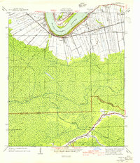
1940 Map of Lagan
USGS Topo · Published 1940About this map
Mississippi River plantations define this 1940 landscape, where large-scale landholdings like Oak Alley Plantation and St James Plantation line the fertile riverfront. The settlement patterns follow the sweeping bends of the river, with Lagan and College Point serving as local hubs near Jefferson College. This survey captures the transition from river-oriented commerce to inland industry, showing the path of the Texas and Pacific railroad and an Old Logging Railroad Grade pushing into the dense backswamps. South of the river, the terrain shifts into a complex network of waterways including Bayou Citamon and Grand Bayou, where small rural schools like Chegby Sch and Peltier Sch were established along the St James Parish and Lafourche Parish line. The map provides a rare view of the river's edge before modern industrialization changed the character of these historic plantation tracts.
Find a feature on this map
36 named features on this map. Tap any name to fly to it.
Don’t see what you’re looking for? This feature index may not catch every label — zoom into the map to look around manually.
Map Details
Editions of this 1940 Lagan Map
2 editions found
Other maps of this area

1892 · Lac Des Allemands
USGS Topo · 1:62,500

1892 · Mount Airy
USGS Topo · 1:62,500

1892 · Donaldsonville
USGS Topo · 1:62,500

1892 · Thibodaux
USGS Topo · 1:62,500

1927 · Thibodaux NW
USGS Topo · 1:31,680

1932 · Lac Des Allemands NW
USGS Topo · 1:31,680

1932 · Lac Des Allemands SW
USGS Topo · 1:31,680

1932 · Thibodaux NE
USGS Topo · 1:31,680

1932 · Thibodaux SE
USGS Topo · 1:31,680

1932 · Thibodaux SW
USGS Topo · 1:31,680