1920s Maps of Louisiana
Explore 7 historic maps of Louisiana from the 1920s. These maps offer a rare glimpse into what life looked like during the 1920s — showing old roads, neighborhoods, homes, and landmarks that have changed or disappeared over time.
Whether you're researching your family's past, planning a metal detecting trip, or studying how Louisiana's landscape evolved across the 1920s, these high-resolution maps are a powerful tool for exploring the history of this region.
- Focus on a specific era: All maps on this page are from the 1920s, giving you a focused view of this time period.
- See what’s changed: Compare century-old streets, trails, and buildings to today's modern landscape using overlays and satellite layers.
- Research with precision: Use these maps for genealogy, historical research, land use analysis, or educational projects.
- View, download, or print: Maps are fully viewable online in high resolution, and can be downloaded or printed for your own records.
Start exploring Louisiana's history through authentic maps from the 1920s. This is your window into the past.
Louisiana maps
(7)- 1921 Map of Natchez
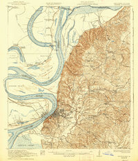
 1921 Natchez1921 Print · USGSThe Mississippi River bluffs and floodplain come alive in this early 1920s survey of the Natchez region and its Louisiana neighbors. Genealogists can trace family roots through numerous sites like Taconey Plantation, the Adams County Poor Farm, and Quitman School.
 - 1921 Map of Nicholson
 1921 Nicholson1921 Print · USGSThe borderlands of Mississippi and Louisiana are captured here in the early 1920s, showing a river-driven landscape of timber and rail. Researchers can trace the riverfront communities of Gainsville and Logtown alongside the historic 3 Notch Road.
 - 1922 Map of Natchez, 1938 Print
 1922 Natchez1938 Print · USGSThe Mississippi River's shifting path at Natchez in the early twentieth century reveals a landscape of working plantations and thriving river ports. Researchers can trace land holdings at Windemere, locate rural sites like the Poor Farm, or follow the Yazoo and Mississippi Valley rail line.2 unique versions available
 - 1922 Map of Sarepta, 1954 Print
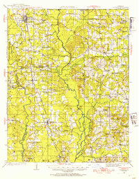 1922 Sarepta1954 Print · USGSUpper Webster Parish in the early 1920s is a landscape of creek-bottom communities and timber-belt settlements. Genealogists can trace family footprints across dozens of rural landmarks, from the Manuel Garcia Grant to Sykes Ferry and Old Shongaloo Church.
 - 1924 Map of Sarepta
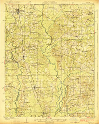 1924 Sarepta1924 Print · USGSNorthern Louisiana during the early twenties is a landscape of rail-linked towns and bayou crossings. Genealogists and local historians can trace family roots through numerous rural landmarks like Beulahs Mt Church, Wise Store, and Old Shongaloo School.
 - 1927 Map of Thibodaux NW
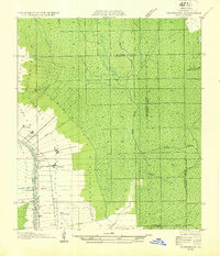 1927 Thibodaux NW1927 Print · USGSAssumption Parish at the end of the 1920s reveals the intricate ribbon-strip land patterns along the bayous. Genealogists and historians can trace family-named settlements like Albemarle, Aurelia, and Bertie, or locate the St Thomas Sch and Woodlawn Ch.
 - 1927 Map of El Dorado
 1927 El Dorado1927 Print · USGSUnion County, Arkansas, is captured here in the late twenties as the oil boom transformed the landscape around El Dorado. Researchers can trace the early footprints of settlements like Caledonia and find rural landmarks such as Old Parker Chapel and Jennys Store.2 unique versions available
End of results
Showing maps 1-7 of 7
Top cities of Louisiana
- New Orleans historical maps
- Baton Rouge historical maps
- Shreveport historical maps
- Metairie historical maps
- Lafayette historical maps
- Saint George historical maps
See more
Top parishes of Louisiana
- Jefferson Parish historical maps
- Orleans Parish historical maps
- Caddo Parish historical maps
- St. Tammany Parish historical maps
- Lafayette Parish historical maps
- Calcasieu Parish historical maps
See more
Frequently asked questions
- What are the different types of historical maps available for Louisiana?
- What is the oldest map of Louisiana?
- Where can I purchase historical maps of Louisiana for my home or office?
- Where can I download high-res historical maps of Louisiana?
- Are there historical topographic maps available for Louisiana?
- Is there historical aerial imagery available for Louisiana?
- Where are historical maps of Louisiana sourced from?