Old Maps of Lafourche Parish, Louisiana
Explore 387 old maps of Lafourche Parish, spanning from 1891 to today. These high-resolution historic maps reveal how streets, neighborhoods, landmarks, and natural features evolved over time — perfect for genealogy, metal detecting, research, and local history exploration.
What you can do with these maps:
- See how Lafourche Parish changed over time: Compare historical maps to modern-day views to trace roads, homesites, rail lines & more.
- View detailed metadata: Each map includes creators, publishers, year, scale, and archive source.
- Overlay maps with satellite & LiDAR: Visualize the past alongside modern tools to explore terrain & human change.
- Trusted historical sources: Maps sourced from the USGS, Library of Congress, and other archives.
- Access maps your way: View online, download high-res files, or order prints for personal or research use.
Start exploring old maps of Lafourche Parish to uncover forgotten places, hidden landmarks, and the deep history beneath your feet.
Lafourche Parish, LA maps
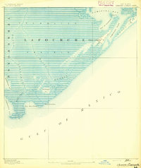
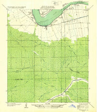
(387)- 1891 Map of Hahnville
 1891 Hahnville1891 Print · USGSSt. Charles Parish was a hub of river and rail commerce in the late nineteenth century, where new tracks began to bridge the gap between New Orleans and the southern bayous. Researchers can trace historic riverfront tracts at Hahnville and Luling or locate family-named landings such as Pecan Grove and Loquer.5 unique versions available
 - 1892 Map of Barataria
 1892 Barataria1892 Print · USGSCoastal Jefferson and Plaquemines parishes appear in the late nineteenth century as a sprawling network of marshlands and navigable bayous. Researchers can trace the early rail influence of the N. O. F. J. & G. I. R. R. and locate family landmarks like John the Fool Island and the settlement of Barataria.3 unique versions available
 - 1892 Map of Cheniere Caminada
 1892 Cheniere Caminada1892 Print · USGSLouisiana's gulf coast appears in the early 1890s, shortly before a catastrophic hurricane forever changed the local landscape. Genealogists can trace the footprint of Cheniere Caminada and the early layout of Grand Isle near Caminada Pass.4 unique versions available
 - 1892 Map of Lac Des Allemands
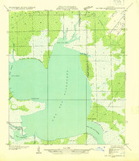
 1892 Lac Des Allemands1892 Print · USGSCoastal Louisiana at the end of the nineteenth century is defined by its massive marsh basins and early rail corridors. Researchers can trace the original routes of the Southern Pacific Railroad and locate specific sites like the Indian Mound or Raceland Station.4 unique versions available
 - 1892 Map of Gibson
 1892 Gibson1892 Print · USGSCoastal Louisiana in the early 1890s is captured here as a landscape of bayous and new rail lines. Genealogists and historians can trace family land along Bayou Black or locate old railway stops at Gibson, Chacahoula, and Schriever.4 unique versions available
 - 1892 Map of Cut-Off
 1892 Cut-Off1892 Print · USGSCoastal Louisiana in the 1890s is defined by its reliance on water for transit and trade. Trace the early settlement patterns of Gheens, Harang, and Cut Off along the historic Bayou Lafourche and its connecting canals.4 unique versions available
 - 1892 Map of Houma
 1892 Houma1892 Print · USGSCoastal Louisiana in the 1890s shows a landscape of waterborne commerce and rising rail lines. Genealogists and historians can trace old homesteads along Bayou Lafourche or study the early street grid of Houma and the path of the Southern Pacific Railroad.4 unique versions available
 - 1892 Map of Creole
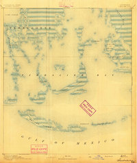
 1892 Creole1892 Print · USGSCoastal Lafourche and Jefferson parishes appear in the early 1890s as a complex of tidal wetlands and prairies. Genealogists and historians can trace the original watercourses of Bayou Lafourche, Little Lake, and the remote Shrimp Ids.4 unique versions available
 - 1892 Map of Thibodaux, 1898 Print
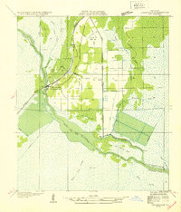
 1892 Thibodaux1898 Print · USGSCajun country at the end of the nineteenth century is defined here by the winding course of Bayou Lafourche and its riverside communities. Genealogists and local historians can trace the early footprints of Thibodeaux and Labadieville alongside rail lines like the Southern Pacific Railroad.3 unique versions available
 - 1893 Map of Fort Livingston
 1893 Fort Livingston1893 Print · USGSThe Louisiana coast in the early 1890s is captured here as a sprawling network of tidal bayous and strategic passes. Local historians can trace maritime markers like Ft. Livingston and the Light on Grand Isle amid a maze of islands.3 unique versions available
 - 1894 Map of Timbalier
 1894 Timbalier1894 Print · USGSCoastal Louisiana at the end of the nineteenth century reveals a shifting world of barrier islands and isolated maritime outposts. Researchers can trace the early positions of the Timbalier Light and small camps such as Philo Brice or Jacko Camp.3 unique versions available
 - 1894 Map of Lake Felicity
 1894 Lake Felicity1894 Print · USGSCoastal Louisiana in the early 1890s reveals a wild landscape of sprawling marshes and intricate bayous at the edge of the Gulf. Researchers can trace historic waterways like Bayou Du Chien and St. Jean Charles Bayou or locate Lake Billiot and Catfish Lake.3 unique versions available
 - 1894 Map of Dulac
 1894 Dulac1894 Print · USGSCoastal Terrebonne Parish appears here in the early 1890s, when life followed the natural rhythms of the bayous and marsh. Researchers can trace early water routes and family settlements near Montegut, Dulac, and the winding Bayou Grand Caillou.3 unique versions available
 - 1897 Map of Gibson
 1897 Gibson1897 Print · USGSCoastal Louisiana in the late nineteenth century was a world defined by its waterways and the rising influence of the rail. Genealogists and researchers can trace the early layout of bayou settlements like Schriever, Ellendale, and Chacahoula along the Southern Pacific Railroad.
 - 1927 Map of Thibodaux NW
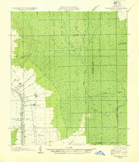 1927 Thibodaux NW1927 Print · USGSAssumption Parish at the end of the 1920s reveals the intricate ribbon-strip land patterns along the bayous. Genealogists and historians can trace family-named settlements like Albemarle, Aurelia, and Bertie, or locate the St Thomas Sch and Woodlawn Ch.
 - 1932 Map of Houma SE
 1932 Houma SE1932 Print · USGSCoastal Louisiana in the early thirties reveals a landscape defined by the intersection of marshland and new navigation projects. Genealogists and local historians can trace family locations near Aragon Plantation, Bisland Cem, and the village of Bourg.
 - 1932 Map of Lac Des Allemands NW
 1932 Lac Des Allemands NW1932 Print · USGSSettlement and swamp meet at Vacherie during the early thirties as the region’s sugar and rail economy thrived between the river and the marsh. Family historians can trace local landmarks like Vacherie Sch, the Texas and Pacific rail line, and Coulee du Cimetiere.
 - 1932 Map of Lac Des Allemands SE
 1932 Lac Des Allemands SE1932 Print · USGSLafourche Parish and the surrounding marshlands are captured in the early 1930s as modern transit began following old rail lines. Researchers can trace the legacy of the sugar and transport economy through landmarks like Roux, the Godchaux Canal, and St Lawrence Ch.
 - 1932 Map of Lac Des Allemands SW
 1932 Lac Des Allemands SW1932 Print · USGSLafourche Parish is captured in the early thirties as a productive landscape of sugar plantations and bayou settlements. Researchers can locate family landmarks like Webster Plantation, trace the route of the Southern Pacific railroad, or find local institutions such as Bush Grove Ch.
 - 1932 Map of Houma SW
 1932 Houma SW1932 Print · USGSCoastal Louisiana at the height of the early thirties shows a region defined by its water-bound industry and growing infrastructure. Genealogists and historians can trace family-named sites like Southdown and Ashland, or locate rural landmarks such as Jerusalem Ch and the Bayou Cane Sch.
 - 1932 Map of Houma NE
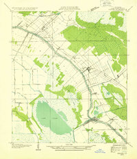 1932 Houma NE1932 Print · USGSLafourche Parish in the early thirties reveals a landscape defined by the serpentine path of Bayou Lafourche and its thriving waterway communities. You can trace early 20th-century life at Lockport and Raceland, or find vanished school sites like Prairie Sch.2 unique versions available
 - 1932 Map of Thibodaux NE
 1932 Thibodaux NE1932 Print · USGSSt. James Parish at the height of the plantation era shows the intricate relationship between the river and the swamp. Genealogists can trace family footprints near Jefferson College or local schools like Peties Sch and Chegby Sch.
 - 1932 Map of Houma NW
 1932 Houma NW1932 Print · USGSLafourche and Terrebonne Parishes appear here in the early 1930s, showing a landscape shaped by linear bayou settlements and drainage canals. Researchers can trace rural community life through sites like St Louis Chapel, Theriot Siding, and Porche Sch.
 - 1932 Map of Lac Des Allemands NE
 1932 Lac Des Allemands NE1932 Print · USGSCoastal Louisiana at the start of the 1930s is revealed through the intricate bayous and marshlands surrounding Lac Des Allemands. Trace the early drainage patterns and landforms from Carlin Pointe to the Vacherie Canal and Bayou Fortier.
 - 1932 Map of Hahnville SW
 1932 Hahnville SW1932 Print · USGSThe St. Charles Parish wetlands come alive in the early 1930s as a complex network of reclamation canals and bayou transport. Trace the development of Des Allemands and find local landmarks like the St Charles Sch and the Southern Pacific rail line.
Showing maps 1-25 of 387
Top cities of Lafourche Parish
Frequently asked questions
- What are the different types of historical maps available for Lafourche Parish?
- What is the oldest map of Lafourche Parish?
- Where can I purchase historical maps of Lafourche Parish for my home or office?
- Where can I download high-res historical maps of Lafourche Parish?
- Are there historical topographic maps available for Lafourche Parish?
- Is there historical aerial imagery available for Lafourche Parish?
- Where are historical maps of Lafourche Parish sourced from?