1950s Maps of Lafourche Parish, Louisiana
Explore 23 historic maps of Lafourche Parish from the 1950s. These maps offer a rare glimpse into what life looked like during the 1950s — showing old roads, neighborhoods, homes, and landmarks that have changed or disappeared over time.
Whether you're researching your family's past, planning a metal detecting trip, or studying how Lafourche Parish's landscape evolved across the 1950s, these high-resolution maps are a powerful tool for exploring the history of this region.
- Focus on a specific era: All maps on this page are from the 1950s, giving you a focused view of this time period.
- See what’s changed: Compare century-old streets, trails, and buildings to today's modern landscape using overlays and satellite layers.
- Research with precision: Use these maps for genealogy, historical research, land use analysis, or educational projects.
- View, download, or print: Maps are fully viewable online in high resolution, and can be downloaded or printed for your own records.
Start exploring Lafourche Parish's history through authentic maps from the 1950s. This is your window into the past.
Lafourche Parish, LA maps
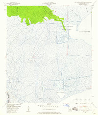
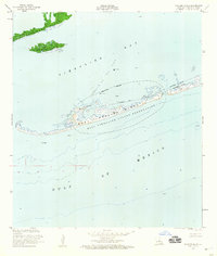
(23)- 1950 Map of Golden Meadow Farms
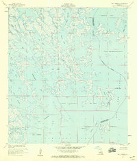
 1950 Golden Meadow Farms1950 Print · USGSLafourche Parish during the mid-century period shows the intensive drainage efforts used to transform the coastal marsh. Genealogists and historians can trace the early layout of Golden Meadow Farms and the paths of the Raphael Canal and Yankee Canal.
 - 1952 Map of Allemands, 1953 Print
 1952 Allemands1953 Print · USGSThe Louisiana bayou country is captured here during the mid-century expansion of the energy industry. Researchers can trace family sites like Shell Mound Cem, see the early Paradis Oil Field, and follow the Southern Pacific line through Allemands.2 unique versions available
 - 1952 Map of Lake Cataouatche West, 1953 Print
 1952 Lake Cataouatche West1953 Print · USGSThe Louisiana wetlands in the early fifties show a landscape of industrial drainage and petroleum exploration. Researchers can trace the mid-century oil infrastructure at Bayou Couba Oil Field or follow timber routes like the Louisiana Cypress Lumber Canal.2 unique versions available
 - 1953 Map of Belle Pass, 1959 Print
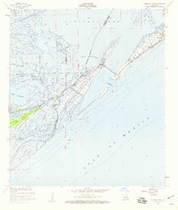
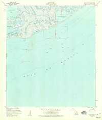 1953 Belle Pass1959 Print · USGSCoastal Lafourche Parish is captured in the mid-fifties as the offshore oil industry begins its expansion into the Gulf. Genealogists and historians can trace early maritime infrastructure at Belle Pass and the industrial works near Bayou Fourchon and Bay Marchand.4 unique versions available
 - 1953 Map of Bay Dosgris, 1959 Print
 1953 Bay Dosgris1959 Print · USGSCoastal Lafourche Parish in the mid-fifties is captured here as a sprawling network of marsh and industrial development. Researchers can trace the early infrastructure of the Bay De Chene Oil Field and the winding course of Grand Bayou and Manila Bayou.3 unique versions available
 - 1953 Map of Jacko Bay, 1959 Print
 1953 Jacko Bay1959 Print · USGSCoastal Louisiana at the height of the mid-century oil boom reveals a landscape of shifting tides and rising industry. Researchers can trace the early footprint of the Lake Barre Oil Field or locate family-named landmarks like Cat Island and Terrebonne Island.3 unique versions available
 - 1953 Map of Calumet Island, 1959 Print
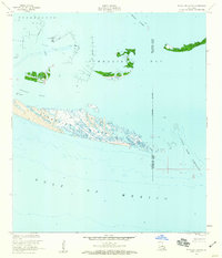
 1953 Calumet Island1959 Print · USGSLafourche Parish's shifting coastline is captured here in the 1950s, documenting the vital barrier islands and emerging offshore industry. Map collectors and researchers can trace the Timbalier Bay Oil Field infrastructure across the East Timbalier Island Reservation.4 unique versions available
 - 1953 Map of Timbalier Island, 1959 Print
 1953 Timbalier Island1959 Print · USGSThe Louisiana coast in the early fifties shows the intersection of barrier island geography and the emerging energy industry. You can trace early industrial infrastructure across Caillou Island, identifying the Caillou Island Oil Field and scattered Oil Tanks among the tides.4 unique versions available
 - 1954 Map of Mink Bayou
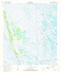
 1954 Mink Bayou1954 Print · USGSCoastal Lafourche Parish is captured here during the mid-1930s, showing the concentration of life along the narrow natural levees of the bayous. Genealogists can trace early homesteads and several Cem locations along Bayou Lafourche and State Highway No. 620.
 - 1954 Map of Morgan City
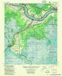
 1954 Morgan City1954 Print · USGSCoastal Louisiana in the mid-fifties shows a dynamic intersection of rail, road, and river traffic centered on the deep waters of Berwick Bay. Researchers can trace old family sites at Fairview Plantation, locate the Bayou L'Ourse Sch., or study the era's energy growth at the Bateman Lake Oil Field.
 - 1954 Map of Pelican Pass
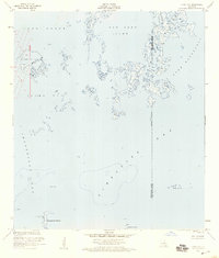
 1954 Pelican Pass1954 Print · USGSThe Louisiana coast at the edge of Lafourche and Terrebonne Parishes is mapped here in the mid-1930s, showing a world of tidal passes and marsh islands. Trace the old waterway names and small camps like Philo, Jacko Camp Bay, and the Cassetete Islands as they existed before decades of shoreline change.
 - 1954 Map of Golden Meadow Farms
 1954 Golden Meadow Farms1954 Print · USGSCoastal Lafourche Parish is captured in the mid-1950s, showing the early infrastructure of Golden Meadow Farms and its drainage canals. Trace the wetlands and historic waterways from Kings Ridge to the waters of Brusle Lake and Little Lake.
 - 1954 Map of Caminada Pass
 1954 Caminada Pass1954 Print · USGSThe barrier islands and bayous of coastal Louisiana are captured here in the mid-1950s before significant modern shoreline erosion. Genealogists and local historians can trace the early layout of Grand Isle, locate a secluded Cemetery, and study the old path of the State Highway through Cheniere Caminada.
 - 1954 Map of Lake Felicity
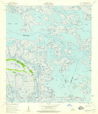
 1954 Lake Felicity1954 Print · USGSCoastal Terrebonne Parish in the mid-1950s is an intricate puzzle of marshes and tidal basins. Genealogists and historians can trace the traditional waterways of the delta, including Bayou Jean Lacroix, Lake Chien, and Lake Trois Jeans.
 - 1955 Map of Hahnville
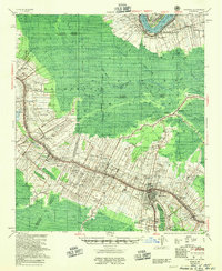
 1955 Hahnville1955 Print · USGSSt. Charles Parish in the mid-1950s shows a landscape balancing river industry with vast coastal wetlands. Genealogists and historians can trace the development of Hahnville and Destrehan or locate rural landmarks like Mt Airy Church and the Davis Crevasse of 1884.
 - 1955 Map of Thibodaux
 1955 Thibodaux1955 Print · USGSCoastal Louisiana in the mid-fifties is defined by the winding Bayou Lafourche and the massive Mississippi River. Genealogists and historians can trace numerous family-named sites and plantation tracts, including Laurel Valley Plantation, the New Belmont Ch, Sch & Cem, and the river landing at Moonshine.
 - 1956 Map of Leeville
 1956 Leeville1956 Print · USGSLafourche Parish's coastal marshes are seen here during the mid-century expansion of the petroleum industry. Genealogists and historians can trace the settlement of Leeville, find the local Cem, and follow the path of State Highway No 620 through the bayous.
 - 1956 Map of Pelican Pass, 1959 Print
 1956 Pelican Pass1959 Print · USGSCoastal Lafourche Parish in the mid-1950s reveals a landscape of tidal marshes and early petroleum exploration. Local historians can trace the foundations of Jacko Camp and search for ruins near Pelican Pass and Casse-Tete Island.4 unique versions available
 - 1956 Map of Bay Tambour, 1959 Print
 1956 Bay Tambour1959 Print · USGSCoastal Lafourche and Jefferson Parishes appear as a maze of marsh and bayous in the mid-1950s. Trace the path of the Southwestern Louisiana Canal and find family-named points like Martigan Point or landmarks such as Andre Island.3 unique versions available
 - 1956 Map of Golden Meadow Farms, 1959 Print
 1956 Golden Meadow Farms1959 Print · USGSCoastal Louisiana marshlands in the mid-1950s reveal a landscape of emerging petroleum industry and traditional bayou waterways. Trace the development of Golden Meadow Farms alongside early infrastructure like the Yankee Canal and numerous Oil Wells.
 - 1957 Map of Caminada Pass, 1959 Print
 1957 Caminada Pass1959 Print · USGSThe Louisiana coast in the mid-fifties reveals a landscape of shifting tides and marshland settlements along the Gulf. Researchers can trace the layout of Cheniere Caminada, find specific Ruins by the pass, and map the intricate drainage of Thunder Bayou.3 unique versions available
 - 1957 Map of Mink Bayou, 1963 Print
 1957 Mink Bayou1963 Print · USGSThe coastal marshes of Lafourche Parish are captured here during a period of expanding energy infrastructure in the late fifties. You can trace the development of the Oil Field and Southwestern Canal alongside natural landmarks like Bay Rambo and Lake Jesse.3 unique versions available
 - 1957 Map of Breton Sound, 1967 Print
 1957 Breton Sound1967 Print · USGSThe Mississippi River delta is captured here in the mid-fifties, showing the fragile marshlands and river-dependent towns of the Louisiana coast. Genealogists and historians can trace riverside settlements like Pointe a la Hache, Pilottown, and Port Sulphur.3 unique versions available
End of results
Showing maps 1-23 of 23
Top cities of Lafourche Parish
Frequently asked questions
- What are the different types of historical maps available for Lafourche Parish?
- What is the oldest map of Lafourche Parish?
- Where can I purchase historical maps of Lafourche Parish for my home or office?
- Where can I download high-res historical maps of Lafourche Parish?
- Are there historical topographic maps available for Lafourche Parish?
- Is there historical aerial imagery available for Lafourche Parish?
- Where are historical maps of Lafourche Parish sourced from?