Old Maps of Golden Meadow, Louisiana
Explore 27 old maps of Golden Meadow, spanning from 1894 to today. These high-resolution historic maps reveal how streets, neighborhoods, landmarks, and natural features evolved over time — perfect for genealogy, metal detecting, research, and local history exploration.
What you can do with these maps:
- See how Golden Meadow changed over time: Compare historical maps to modern-day views to trace roads, homesites, rail lines & more.
- View detailed metadata: Each map includes creators, publishers, year, scale, and archive source.
- Overlay maps with satellite & LiDAR: Visualize the past alongside modern tools to explore terrain & human change.
- Trusted historical sources: Maps sourced from the USGS, Library of Congress, and other archives.
- Access maps your way: View online, download high-res files, or order prints for personal or research use.
Start exploring old maps of Golden Meadow to uncover forgotten places, hidden landmarks, and the deep history beneath your feet.
Golden Meadow, LA maps
(27)- 1894 Map of Lake Felicity
 1894 Lake Felicity1894 Print · USGSCoastal Louisiana in the early 1890s reveals a wild landscape of sprawling marshes and intricate bayous at the edge of the Gulf. Researchers can trace historic waterways like Bayou Du Chien and St. Jean Charles Bayou or locate Lake Billiot and Catfish Lake.3 unique versions available
 - 1935 Map of Bay Courant
 1935 Bay Courant1935 Print · USGSThe coastal wetlands of Lafourche and Terrebonne Parishes are captured here in the mid-1930s, showing a complex network of bayous and bays. Researchers can trace the original paths of Bayou Labourche, Jean Plaisance Bay, and the wide waters of Lake Raccourci.
 - 1935 Map of Golden Meadow
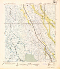 1935 Golden Meadow1935 Print · USGSCoastal Louisiana life centers on the natural levee of Bayou Lafourche during the mid-1930s. Genealogists and local historians can trace family-named schools and early settlements like Lapit, Sandas, and the Green Church.
 - 1939 Map of Lake Felicity, 1961 Print
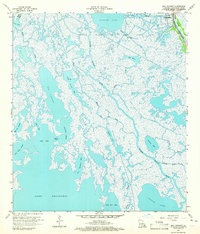
 1939 Lake Felicity1961 Print · USGSCoastal Lafourche Parish in the late 1930s is defined by its vibrant bayou culture and linear settlements. Genealogists and historians can trace the foundations of Galliano and Golden Meadow, finding local landmarks like Cheramie Cem and the Valere Guidry Sch.
 - 1941 Map of Lake Felicity
 1941 Lake Felicity1941 Print · USGSCoastal Louisiana at the end of the thirties reveals a landscape of marshland life centered on Bayou Lafourche. Researchers can trace family roots at Golden Meadow or locate rural landmarks like Cheramie Cem and Naquin Sch.
 - 1944 Map of Lake Felicity
 1944 Lake Felicity1944 Print · USGSCoastal Lafourche and Terrebonne parishes appear here in the late thirties, defined by the narrow ridge of Golden Meadow and the expansive delta wetlands. Researchers can locate family landmarks like the Cheramie Cem, Hebert Cem, and the Valere Guidry Sch along the bayou.
 - 1945 Map of New Orleans
 1945 New Orleans1945 Print · USGSCoastal Louisiana and the Mississippi delta are captured here just after the war, showing the region's transition into a modern industrial and transit hub. Genealogists can trace family settlements along Bayou Teche or identify rail stops for the Illinois Central and Texas & Pacific lines.
 - 1963 Map of New Orleans
 1963 New Orleans1963 Print · USGSCoastal Louisiana in the mid-twentieth century reveals a complex world of bayou settlements, expanding oil fields, and vital rail networks. Genealogists and historians can trace family roots through river towns like Thibodaux or follow the Southern Pacific line through Franklin and Patterson.4 unique versions available
 - 1964 Map of Bay Courant, 1965 Print
 1964 Bay Courant1965 Print · USGSThe coastal marsh of Lafourche Parish in the mid-sixties shows the industrial footprint of the Golden Meadow Oil and Gas Field. Genealogists and local historians can locate Sunnyside Cem and trace the many named waterways like Chinaman Bayou and Grand Bayou Blue.2 unique versions available
 - 1964 Map of Golden Meadow, 1965 Print
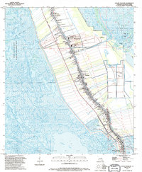
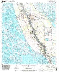
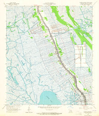 1964 Golden Meadow1965 Print · USGSCoastal Lafourche Parish in the mid-sixties shows a classic ribbon settlement pattern along the banks of Bayou Lafourche. Researchers can trace family history through local landmarks like St Joseph Ch and numerous family plots such as Williams Cem and Pitre Cem.3 unique versions available
 - 1964 Map of Lake Felicity, 1965 Print
 1964 Lake Felicity1965 Print · USGSCoastal Louisiana in the mid-sixties shows a landscape defined by the narrow ridge of Bayou Lafourche and an expansive network of wetlands. Genealogists and historians can trace family-named sites like Williams Cem, St Peters Ch, and the Lower Pointe au Chien Sch.3 unique versions available
 - 1966 Map of New Orleans
 1966 New Orleans1966 Print · USGSCoastal Louisiana in the mid-1960s reveals a transition from traditional bayou life to an intensive offshore oil and gas economy. Researchers can trace the rail lines of the Southern Pacific RR through Morgan City or locate the Eugene Island Lighthouse among the delta's shifting marshes.
 - 1983 Map of Terrebonne Bay
 1983 Terrebonne Bay1983 Print · USGSThe Louisiana coast in the early 1980s reveals a labyrinth of bayous and barrier islands before decades of significant shoreline change. Researchers can trace the development of the energy industry and coastal settlements like Galliano and Montegut alongside the Isles Dernieres.
 - 1994 Map of Bay Courant
 1994 Bay Courant1994 Print · USGSThe Louisiana coast near Golden Meadow is captured in the mid-1990s, revealing a landscape defined by industrial expansion and shifting wetlands. Genealogists and local historians can trace the Surgney Cem and early gas fields like the Courant Bay Gas Field.
 - 1994 Map of Golden Meadow, 1995 Print
 1994 Golden Meadow1995 Print · USGSIn the mid-nineties, the communities of Lafourche Parish remained tightly clustered along the winding course of the bayou. Genealogists and local historians can trace family ties through numerous sites like the St Joseph Ch Cem, Hebert Cem, and the Golden Meadow Voc-Tech Sch.
 - 1998 Map of Golden Meadow, 2000 Print
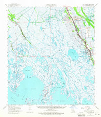
 1998 Golden Meadow2000 Print · USGSCoastal Lafourche Parish life in the late nineties centered on the high ground flanking the bayou while industry pushed deep into the surrounding marsh. Researchers can locate numerous family burial sites like Williams Cem and Hébert Cem or trace the development of Galliano.
 - 1998 Map of Bay Courant, 2002 Print
 1998 Bay Courant2002 Print · USGSCoastal Lafourche Parish appears here in the late 1990s as a complex network of oil fields, bayous, and fragile marshlands. Researchers can trace the industrial footprint of the Golden Meadow Oil and Gas Field and locate local landmarks like the Surgney Cem and Chinaman Bayou.
 - 2012 Map of Bay Courant, 2012 Print
 2012 Bay Courant2012 Print · USGSCovers Golden Meadow, including Lafourche Parish, United States, and other nearby areas
 - 2012 Map of Golden Meadow, 2012 Print
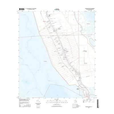
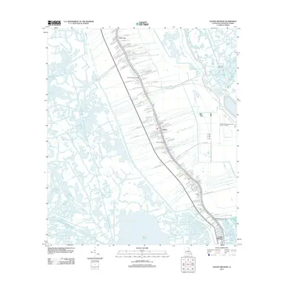 2012 Golden Meadow2012 Print · USGSCovers Golden Meadow, including Galliano, Belle Amie, and other nearby areas
 - 2015 Map of Bay Courant, 2015 Print
 2015 Bay Courant2015 Print · USGSCovers Golden Meadow, including Lafourche Parish, United States, and other nearby areas
 - 2015 Map of Golden Meadow, 2015 Print
 2015 Golden Meadow2015 Print · USGSCovers Golden Meadow, including Galliano, Belle Amie, and other nearby areas
 - 2018 Map of Golden Meadow, 2018 Print
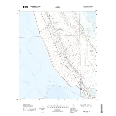 2018 Golden Meadow2018 Print · USGSCovers Golden Meadow, including Galliano, Belle Amie, and other nearby areas
 - 2018 Map of Bay Courant, 2018 Print
 2018 Bay Courant2018 Print · USGSCovers Golden Meadow, including Lafourche Parish, United States, and other nearby areas
 - 2020 Map of Golden Meadow, 2020 Print
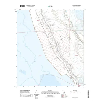 2020 Golden Meadow2020 Print · USGSCovers Golden Meadow, including Galliano, Belle Amie, and other nearby areas
 - 2020 Map of Bay Courant, 2020 Print
 2020 Bay Courant2020 Print · USGSCovers Golden Meadow, including Lafourche Parish, United States, and other nearby areas
Showing maps 1-25 of 27
Top cities near Golden Meadow
Frequently asked questions
- What are the different types of historical maps available for Golden Meadow?
- What is the oldest map of Golden Meadow?
- Where can I purchase historical maps of Golden Meadow for my home or office?
- Where can I download high-res historical maps of Golden Meadow?
- Are there historical topographic maps available for Golden Meadow?
- Is there historical aerial imagery available for Golden Meadow?
- Where are historical maps of Golden Meadow sourced from?