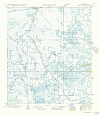
1956 Map of Leeville
USGS Topo · Published 1956About this map
Leeville serves as the primary hub of activity in this coastal Lafourche Parish landscape, situated along the vital corridor of Bayou Lafourche. The geography is a complex network of natural waterways and industrial interventions, where the Southwestern Louisiana Canal and Milliets Canal cut through the marsh toward Hackberry Bay. An Oil Field north of the main settlement underscores the emergence of the petroleum industry in the mid-20th century. Local family history is rooted near the Cem and the small landing at Grey. The transition from freshwater bayous like Bayou Moreau and Bayou Cochon to saltier reaches like Timbalier Bay and the Gulf of Mexico illustrates a landscape defined by its precarious relationship with the rising tide and shifting silt.
Find a feature on this map
22 named features on this map. Tap any name to fly to it.
Don’t see what you’re looking for? This feature index may not catch every label — zoom into the map to look around manually.
Map Details
Editions of this 1956 Leeville Map
This is the sole edition of this map. No revisions or reprints were ever made.
Other maps of this area

1892 · Cheniere Caminada
USGS Topo · 1:62,500

1892 · Creole
USGS Topo · 1:62,500

1894 · Timbalier
USGS Topo · 1:62,500

1894 · Lake Felicity
USGS Topo · 1:62,500

1935 · Bay Courant
USGS Topo · 1:31,680

1935 · Pelican Pass
USGS Topo · 1:31,680

1935 · Mink Bayou
USGS Topo · 1:31,680

1935 · Calumet Island
USGS Topo · 1:31,680

1935 · Leeville
USGS Topo · 1:31,680

1939 · Lake Felicity
USGS Topo · 1:62,500