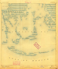
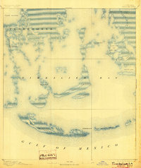
1894 Map of Timbalier
USGS Topo · Published 1894About this map
Timbalier Bay dominates this coastal landscape, showing the complex network of barrier islands and marshy inlets along the Gulf of Mexico at the end of the nineteenth century. Surveyed by H. L. Baldwin Jr. and the U.S. Coast and Geodetic Survey, the map details a fragile environment where tidal passes like Jacko Pass and John Batiste Pass carve through the shoreline. Human presence is sparse but specific, marked by the lonely Timbalier Lt. H. and small outposts like Philo Brice and Jacko Camp. These names suggest a local economy tied to the sea, likely fishing or trapping, positioned near sheltered waters like Jacko Camp Bay and Pierle Bay. The map captures the configuration of Timbalier Island and East Timbalier Island before decades of coastal erosion reshaped the Louisiana delta.
Find a feature on this map
22 named features on this map. Tap any name to fly to it.
Don’t see what you’re looking for? This feature index may not catch every label — zoom into the map to look around manually.
Map Details
Editions of this 1894 Timbalier Map
3 editions found

Other maps of this area
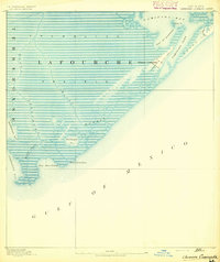
1892 · Cheniere Caminada
USGS Topo · 1:62,500

1892 · Creole
USGS Topo · 1:62,500

1894 · Lake Felicity
USGS Topo · 1:62,500

1894 · Dulac
USGS Topo · 1:62,500

1935 · Bourbeux
USGS Topo · 1:31,680

1935 · Timbalier Island
USGS Topo · 1:31,680

1935 · Bay Courant
USGS Topo · 1:31,680

1935 · Pelican Pass
USGS Topo · 1:31,680

1935 · Mink Bayou
USGS Topo · 1:31,680

1935 · Calumet Island
USGS Topo · 1:31,680