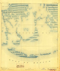
1894 Map of Timbalier
USGS Topo · Published 1904About this map
The coastal marshlands and barrier islands of Terrebonne Parish are meticulously charted here before the modern era of significant shoreline erosion. Centered on Timbalier Bay, the survey captures a complex network of waterways including Jacko Pass and John Batiste Pass, which served as vital corridors for coastal navigation and the regional fishing economy. The presence of the Timbalier Lt. H. on the primary barrier reef underscores the maritime importance of this stretch of the Gulf of Mexico.
Find a feature on this map
21 named features on this map. Tap any name to fly to it.
Don’t see what you’re looking for? This feature index may not catch every label — zoom into the map to look around manually.
Map Details
Editions of this 1894 Timbalier Map
3 editions found
Other maps of this area

1892 · Cheniere Caminada
USGS Topo · 1:62,500

1892 · Creole
USGS Topo · 1:62,500

1894 · Timbalier
USGS Topo · 1:62,500

1894 · Lake Felicity
USGS Topo · 1:62,500

1894 · Dulac
USGS Topo · 1:62,500

1935 · Bourbeux
USGS Topo · 1:31,680

1935 · Timbalier Island
USGS Topo · 1:31,680

1935 · Bay Courant
USGS Topo · 1:31,680

1935 · Pelican Pass
USGS Topo · 1:31,680

1935 · Mink Bayou
USGS Topo · 1:31,680