1990s Maps of Lafourche Parish, Louisiana
Explore 41 historic maps of Lafourche Parish from the 1990s. These maps offer a rare glimpse into what life looked like during the 1990s — showing old roads, neighborhoods, homes, and landmarks that have changed or disappeared over time.
Whether you're researching your family's past, planning a metal detecting trip, or studying how Lafourche Parish's landscape evolved across the 1990s, these high-resolution maps are a powerful tool for exploring the history of this region.
- Focus on a specific era: All maps on this page are from the 1990s, giving you a focused view of this time period.
- See what’s changed: Compare century-old streets, trails, and buildings to today's modern landscape using overlays and satellite layers.
- Research with precision: Use these maps for genealogy, historical research, land use analysis, or educational projects.
- View, download, or print: Maps are fully viewable online in high resolution, and can be downloaded or printed for your own records.
Start exploring Lafourche Parish's history through authentic maps from the 1990s. This is your window into the past.
Lafourche Parish, LA maps
(41)- 1993 Map of Barataria Pass, 1994 Print
 1993 Barataria Pass1994 Print · USGSCoastal Jefferson Parish in the early nineties reveals a landscape where maritime history meets the energy industry. Researchers can trace the layout of Grand Isle, locate the Ft Livingston Ruins, and identify the structures within the Queen Bess Island Oil and Gas Field.
 - 1994 Map of Leeville
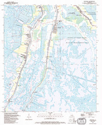
 1994 Leeville1994 Print · USGSThe coastal marshlands of Lafourche Parish in the mid-1990s are defined here by industrial outposts and a network of maritime canals. Researchers can trace the development of Leeville, the expansive Leeville Oil and Gas Field, and the Port Fourchon Water Tank.
 - 1994 Map of Montegut
 1994 Montegut1994 Print · USGSCoastal Terrebonne Parish in the 1990s shows a landscape of bayou-side settlements and vast wetlands. Genealogists can trace family names at Sarah Plantation, Thibodaux Cem, and the St Charles Borromeo Ch along the Lafourche Parish line.
 - 1994 Map of Pelican Pass
 1994 Pelican Pass1994 Print · USGSCoastal Lafourche Parish is captured here in the mid-1990s, showcasing a landscape defined by tidewater bayous and large-scale petroleum extraction. Researchers can locate offshore platforms across Lake Raccourci and trace local landmarks like Philo Brice Islands and Wrong Name Pass.
 - 1994 Map of Bay Tambour
 1994 Bay Tambour1994 Print · USGSLafourche and Jefferson Parish coastlines are captured here in the mid-1990s, illustrating a landscape shaped by water and industry. Researchers can trace the footprint of the Fishermans Bay Gas Field and locate coastal points like Martigan Point or Point des Ilettes.
 - 1994 Map of Caminada Pass
 1994 Caminada Pass1994 Print · USGSThe barrier islands and wetlands of southern Louisiana come to life in this mid-nineties survey of the Gulf coast. Trace family history and maritime industry through labels for Grand Isle, the Cem at Cheniere Caminada, and the Block 16 Oil and Gas Field.
 - 1994 Map of Calumet Island
 1994 Calumet Island1994 Print · USGSThe Louisiana coast in the early 1990s was a landscape defined by barrier islands and heavy offshore industry. Trace the extensive infrastructure of the Timbalier Bay Oil and Gas Field, from the Seawall on East Timbalier Island to isolated platforms.
 - 1994 Map of Bay Courant
 1994 Bay Courant1994 Print · USGSThe Louisiana coast near Golden Meadow is captured in the mid-1990s, revealing a landscape defined by industrial expansion and shifting wetlands. Genealogists and local historians can trace the Surgney Cem and early gas fields like the Courant Bay Gas Field.
 - 1994 Map of Jacko Bay
 1994 Jacko Bay1994 Print · USGSThe Louisiana coastline in the early nineties is captured here as a landscape defined by offshore energy and tidal waters. Trace the dense network of platforms across the Lake Barre Oil and Gas Field and find landmarks like Terrebonne Island.
 - 1994 Map of Bay Dosgris
 1994 Bay Dosgris1994 Print · USGSThe Louisiana coastal marshes come alive in this mid-nineties survey of the Lafourche-Jefferson border. Trace the intersection of industry and isolation through the Alombro Cem and the sprawling Manila Village Oil and Gas Field.
 - 1994 Map of Lake Bully Camp
 1994 Lake Bully Camp1994 Print · USGSCoastal wetlands and industrial sites define this corner of Louisiana in the early nineties. Researchers can trace the intersection of marsh life and energy extraction through landmarks like The Oak Ch, the Bully Camp Gas and Oil Field, and Lake Bully Camp.
 - 1994 Map of Timbalier Island
 1994 Timbalier Island1994 Print · USGSThe Louisiana coast in the early nineties reveals a landscape of heavy industry and shifting barrier islands. Trace the density of the Caillou Island Oil and Gas Field and find Oil Platforms near Timbalier Island.
 - 1994 Map of Lake Felicity
 1994 Lake Felicity1994 Print · USGSCoastal Terrebonne Parish in the early nineties is a labyrinth of interconnected marshes and open water. Researchers can trace the industrial layout of the Bayou Jean Lacroix Oil and Gas Field and explore family-named waterways like Lake Billiot and Lake Trois Jeans.
 - 1994 Map of Belle Pass
 1994 Belle Pass1994 Print · USGSCoastal Lafourche Parish enters the mid-nineties as a vital industrial gateway where the bayou meets the sea. Researchers can trace the development of Port Fourchon and the vast infrastructure of the Block 2 Oil and Gas Field and Belle Pass.
 - 1994 Map of Golden Meadow Farms
 1994 Golden Meadow Farms1994 Print · USGSCoastal Lafourche Parish appears here in the early nineties, revealing a landscape where bayou communities meet large-scale energy infrastructure. Researchers can trace the development of Golden Meadow and explore the waterways of Bayou L'Ours and Lake Enfermer.
 - 1994 Map of Mink Bayou, 1995 Print
 1994 Mink Bayou1995 Print · USGSCoastal Louisiana in the mid-nineties is captured here as a landscape of industrial marshland and traditional bayou life. Genealogists and local historians can locate the Smith Mem Shrine and family landmarks like Griffith Cems or Cheramie Cem near the banks of Bayou Lafourche.
 - 1994 Map of Golden Meadow, 1995 Print
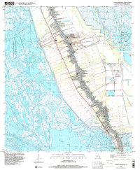
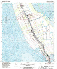 1994 Golden Meadow1995 Print · USGSIn the mid-nineties, the communities of Lafourche Parish remained tightly clustered along the winding course of the bayou. Genealogists and local historians can trace family ties through numerous sites like the St Joseph Ch Cem, Hebert Cem, and the Golden Meadow Voc-Tech Sch.
 - 1994 Map of Amelia, 1998 Print
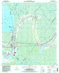 1994 Amelia1998 Print · USGSCoastal Louisiana in the mid-nineties shows an intricate landscape of energy extraction and waterborne commerce centered on Amelia. Researchers can trace the industrial footprint of the Amelia Gas Field and locate local landmarks like St Andrews Cem and the Indian Mound.
 - 1998 Map of Houma, 2000 Print
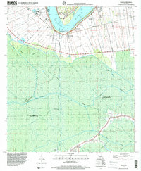
 1998 Houma2000 Print · USGSCoastal Louisiana settlement patterns are on full display in this late-nineties survey of the Terrebonne Parish hub. Researchers can trace family history through a network of local landmarks like Myrtle Grove Cem, Jerusalem Ch, and the Agricultural Experiment Station.
 - 1998 Map of Golden Meadow, 2000 Print
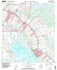
 1998 Golden Meadow2000 Print · USGSCoastal Lafourche Parish life in the late nineties centered on the high ground flanking the bayou while industry pushed deep into the surrounding marsh. Researchers can locate numerous family burial sites like Williams Cem and Hébert Cem or trace the development of Galliano.
 - 1998 Map of Lagan, 2000 Print
 1998 Lagan2000 Print · USGSThe Mississippi River's legendary plantation country is captured here during the late 1990s as industrial and agricultural worlds intersect. Genealogists can trace historic estates like Oak Alley and Bessie K or locate family sites at Roseland Cem and St Lukes Ch.
 - 1998 Map of Savoie, 2000 Print
 1998 Savoie2000 Print · USGSThe bayou country of Lafourche and Terrebonne Parishes is captured here in the late nineties, showing a landscape defined by water and industry. Researchers can trace family history through sites like St Louis Chapel, Bell Cem, and the settlement of Savoie.
 - 1998 Map of Gibson, 2000 Print
 1998 Gibson2000 Print · USGSThe Louisiana bayou country is captured here in the late nineties as a complex network of wetlands and energy industry. Genealogists and researchers can trace the settlements at Gibson and Oak Forest or locate old community landmarks like Rose Hill Ch and Beulah Ch.
 - 1998 Map of Gray, 2000 Print
 1998 Gray2000 Print · USGSCoastal Louisiana's Terrebonne Parish is captured here at the end of the millennium, showing a landscape defined by historic plantation lands and marshy bayous. Researchers can trace the legacy of sites like Magnolia Plantation and Rebecca Plantation or locate family plots at the Garden of Memories Cemetery and St Lukes Church and Cemetery.
 - 1998 Map of Lockport, 2000 Print
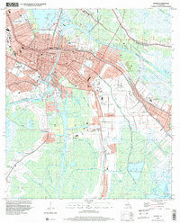
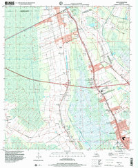
 1998 Lockport2000 Print · USGSBayou Lafourche defines the late twentieth-century landscape of this parish as communities grew along its winding banks. Genealogists and historians can trace the developments of Lockport, Raceland, and Mathews alongside landmarks like Raceland High Sch and the Forty Arpent Canal.
Showing maps 1-25 of 41
Top cities of Lafourche Parish
Frequently asked questions
- What are the different types of historical maps available for Lafourche Parish?
- What is the oldest map of Lafourche Parish?
- Where can I purchase historical maps of Lafourche Parish for my home or office?
- Where can I download high-res historical maps of Lafourche Parish?
- Are there historical topographic maps available for Lafourche Parish?
- Is there historical aerial imagery available for Lafourche Parish?
- Where are historical maps of Lafourche Parish sourced from?