1930s Maps of Lafourche Parish, Louisiana
Explore 28 historic maps of Lafourche Parish from the 1930s. These maps offer a rare glimpse into what life looked like during the 1930s — showing old roads, neighborhoods, homes, and landmarks that have changed or disappeared over time.
Whether you're researching your family's past, planning a metal detecting trip, or studying how Lafourche Parish's landscape evolved across the 1930s, these high-resolution maps are a powerful tool for exploring the history of this region.
- Focus on a specific era: All maps on this page are from the 1930s, giving you a focused view of this time period.
- See what’s changed: Compare century-old streets, trails, and buildings to today's modern landscape using overlays and satellite layers.
- Research with precision: Use these maps for genealogy, historical research, land use analysis, or educational projects.
- View, download, or print: Maps are fully viewable online in high resolution, and can be downloaded or printed for your own records.
Start exploring Lafourche Parish's history through authentic maps from the 1930s. This is your window into the past.
Lafourche Parish, LA maps
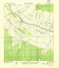
(28)- 1932 Map of Houma SE
 1932 Houma SE1932 Print · USGSCoastal Louisiana in the early thirties reveals a landscape defined by the intersection of marshland and new navigation projects. Genealogists and local historians can trace family locations near Aragon Plantation, Bisland Cem, and the village of Bourg.
 - 1932 Map of Lac Des Allemands NW
 1932 Lac Des Allemands NW1932 Print · USGSSettlement and swamp meet at Vacherie during the early thirties as the region’s sugar and rail economy thrived between the river and the marsh. Family historians can trace local landmarks like Vacherie Sch, the Texas and Pacific rail line, and Coulee du Cimetiere.
 - 1932 Map of Lac Des Allemands SE
 1932 Lac Des Allemands SE1932 Print · USGSLafourche Parish and the surrounding marshlands are captured in the early 1930s as modern transit began following old rail lines. Researchers can trace the legacy of the sugar and transport economy through landmarks like Roux, the Godchaux Canal, and St Lawrence Ch.
 - 1932 Map of Lac Des Allemands SW
 1932 Lac Des Allemands SW1932 Print · USGSLafourche Parish is captured in the early thirties as a productive landscape of sugar plantations and bayou settlements. Researchers can locate family landmarks like Webster Plantation, trace the route of the Southern Pacific railroad, or find local institutions such as Bush Grove Ch.
 - 1932 Map of Houma SW
 1932 Houma SW1932 Print · USGSCoastal Louisiana at the height of the early thirties shows a region defined by its water-bound industry and growing infrastructure. Genealogists and historians can trace family-named sites like Southdown and Ashland, or locate rural landmarks such as Jerusalem Ch and the Bayou Cane Sch.
 - 1932 Map of Houma NE
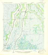
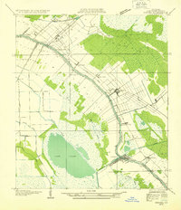 1932 Houma NE1932 Print · USGSLafourche Parish in the early thirties reveals a landscape defined by the serpentine path of Bayou Lafourche and its thriving waterway communities. You can trace early 20th-century life at Lockport and Raceland, or find vanished school sites like Prairie Sch.2 unique versions available
 - 1932 Map of Thibodaux NE
 1932 Thibodaux NE1932 Print · USGSSt. James Parish at the height of the plantation era shows the intricate relationship between the river and the swamp. Genealogists can trace family footprints near Jefferson College or local schools like Peties Sch and Chegby Sch.
 - 1932 Map of Houma NW
 1932 Houma NW1932 Print · USGSLafourche and Terrebonne Parishes appear here in the early 1930s, showing a landscape shaped by linear bayou settlements and drainage canals. Researchers can trace rural community life through sites like St Louis Chapel, Theriot Siding, and Porche Sch.
 - 1932 Map of Lac Des Allemands NE
 1932 Lac Des Allemands NE1932 Print · USGSCoastal Louisiana at the start of the 1930s is revealed through the intricate bayous and marshlands surrounding Lac Des Allemands. Trace the early drainage patterns and landforms from Carlin Pointe to the Vacherie Canal and Bayou Fortier.
 - 1932 Map of Hahnville SW
 1932 Hahnville SW1932 Print · USGSThe St. Charles Parish wetlands come alive in the early 1930s as a complex network of reclamation canals and bayou transport. Trace the development of Des Allemands and find local landmarks like the St Charles Sch and the Southern Pacific rail line.
 - 1932 Map of Thibodaux SE
 1932 Thibodaux SE1932 Print · USGSLafourche Parish is captured in the early 1930s, revealing a landscape of historic bayou settlements and extensive sugar plantations. Genealogists can trace family lands and community landmarks from Laurel Valley Plantation to Blue Lily Cem and the Choupic Sch.
 - 1932 Map of Thibodaux SW
 1932 Thibodaux SW1932 Print · USGSBayou Lafourche during the early thirties is a landscape of expansive sugar estates and bustling rail lines. Genealogists can locate family lands and landmarks like Labadieville, Cedar Grove Plantation, and the Brule Guillot Sch.
 - 1935 Map of Viguerie Canal
 1935 Viguerie Canal1935 Print · USGSThe Louisiana wetlands in the mid-1930s reveal a landscape of coastal bayous and early engineering. Trace the historic route of State Highway No. 968 as it winds alongside Bayou Pointe Au Chien and Lake Bully Camp.
 - 1935 Map of Montegut
 1935 Montegut1935 Print · USGSCoastal Terrebonne Parish comes to life in the mid-1930s, documenting a time when bayou-side settlements were the heart of the region. Genealogists and local historians can trace early footprints at Sarah Plantation, the Dugas Cem, and La Cache School.
 - 1935 Map of Timbalier Island
 1935 Timbalier Island1935 Print · USGSThe Louisiana coastline in the mid-1930s reveals a complex system of barrier islands and marshy bays before decades of significant environmental change. Trace the early shoreline of Timbalier Island and locate survey landmarks like James, King 2, and the Casse-Tete Islands.
 - 1935 Map of Morgan City
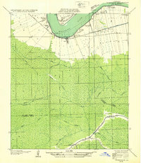
 1935 Morgan City1935 Print · USGSIn the mid-thirties, the Atchafalaya delta was a vital crossroads of the Old Spanish Trail and Southern Pacific rail lines. Genealogists and historians can trace family locations from Fairview Plantation to the Bradley Family Cem and the Bayou Black Settlement.
 - 1935 Map of Bay Courant
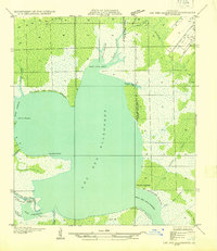
 1935 Bay Courant1935 Print · USGSThe coastal wetlands of Lafourche and Terrebonne Parishes are captured here in the mid-1930s, showing a complex network of bayous and bays. Researchers can trace the original paths of Bayou Labourche, Jean Plaisance Bay, and the wide waters of Lake Raccourci.
 - 1935 Map of Golden Meadow
 1935 Golden Meadow1935 Print · USGSCoastal Louisiana life centers on the natural levee of Bayou Lafourche during the mid-1930s. Genealogists and local historians can trace family-named schools and early settlements like Lapit, Sandas, and the Green Church.
 - 1935 Map of Pelican Pass
 1935 Pelican Pass1935 Print · USGSCoastal Lafourche and Terrebonne parishes are captured in the mid-1930s, showing a labyrinth of marsh and bayous before significant land loss. Researchers can locate remote settlements like Philo and Tete or navigate the waters of Wrong Name Pass and Blue Bayou.
 - 1935 Map of Mink Bayou
 1935 Mink Bayou1935 Print · USGSCoastal Lafourche Parish in the mid-1930s shows a landscape of deep marshes and emerging bayous before the modern era of land loss. Researchers can trace historic family burial sites at Cem and explore the early path of State Highway No 620 alongside Bayou Lafourche.
 - 1935 Map of Calumet Island
 1935 Calumet Island1935 Print · USGSThe coastal marshes of Lafourche Parish are documented in the mid-1930s, showing the complex boundary of the Louisiana shoreline. Researchers can trace the position of the Timbalier L. H. lighthouse and the early configuration of Calumet Island and East Timbalier Island.
 - 1935 Map of Leeville
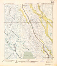
 1935 Leeville1935 Print · USGSThe coastal marshlands of Lafourche Parish are captured here during a period of transition as the early oil industry began to shape the landscape. Researchers can trace the original routes along Bayou Lafourche and locate the local Cem or the Oil Field near Leeville.
 - 1938 Map of Labadieville
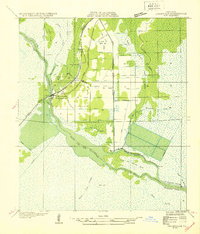
 1938 Labadieville1938 Print · USGSAssumption Parish at the end of the Depression era remains a landscape of sprawling cane plantations and active bayou commerce. Genealogists and historians can trace family locations from Labadieville to rural outposts like Brule Guillot and New Belmont Ch.
 - 1938 Map of Lafourche
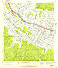
 1938 Lafourche1938 Print · USGSThe Bayou Lafourche corridor is captured here in the late 1930s, showing a landscape defined by its historic sugar plantations and railway junctions. Genealogists and researchers can trace family lands and rural landmarks such as Morningstar Ch, Greenwood Plantation, and the settlement of Naquin.
 - 1939 Map of Cut-Off, 1956 Print
 1939 Cut-Off1956 Print · USGSLafourche Parish marshlands are meticulously detailed here in the late 1930s, showing the settlement string along the bayou levees. Genealogists can locate family landmarks like Bourgeois Sch, Sacred Heart Ch, and the reclaimed lands of Delta Farms.
Showing maps 1-25 of 28
Top cities of Lafourche Parish
Frequently asked questions
- What are the different types of historical maps available for Lafourche Parish?
- What is the oldest map of Lafourche Parish?
- Where can I purchase historical maps of Lafourche Parish for my home or office?
- Where can I download high-res historical maps of Lafourche Parish?
- Are there historical topographic maps available for Lafourche Parish?
- Is there historical aerial imagery available for Lafourche Parish?
- Where are historical maps of Lafourche Parish sourced from?