1890s Maps of Lafourche Parish, Louisiana
Explore 14 historic maps of Lafourche Parish from the 1890s. These maps offer a rare glimpse into what life looked like during the 1890s — showing old roads, neighborhoods, homes, and landmarks that have changed or disappeared over time.
Whether you're researching your family's past, planning a metal detecting trip, or studying how Lafourche Parish's landscape evolved across the 1890s, these high-resolution maps are a powerful tool for exploring the history of this region.
- Focus on a specific era: All maps on this page are from the 1890s, giving you a focused view of this time period.
- See what’s changed: Compare century-old streets, trails, and buildings to today's modern landscape using overlays and satellite layers.
- Research with precision: Use these maps for genealogy, historical research, land use analysis, or educational projects.
- View, download, or print: Maps are fully viewable online in high resolution, and can be downloaded or printed for your own records.
Start exploring Lafourche Parish's history through authentic maps from the 1890s. This is your window into the past.
Lafourche Parish, LA maps
(14)- 1891 Map of Hahnville
 1891 Hahnville1891 Print · USGSSt. Charles Parish was a hub of river and rail commerce in the late nineteenth century, where new tracks began to bridge the gap between New Orleans and the southern bayous. Researchers can trace historic riverfront tracts at Hahnville and Luling or locate family-named landings such as Pecan Grove and Loquer.5 unique versions available
 - 1892 Map of Barataria
 1892 Barataria1892 Print · USGSCoastal Jefferson and Plaquemines parishes appear in the late nineteenth century as a sprawling network of marshlands and navigable bayous. Researchers can trace the early rail influence of the N. O. F. J. & G. I. R. R. and locate family landmarks like John the Fool Island and the settlement of Barataria.3 unique versions available
 - 1892 Map of Cheniere Caminada
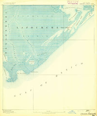 1892 Cheniere Caminada1892 Print · USGSLouisiana's gulf coast appears in the early 1890s, shortly before a catastrophic hurricane forever changed the local landscape. Genealogists can trace the footprint of Cheniere Caminada and the early layout of Grand Isle near Caminada Pass.4 unique versions available
 - 1892 Map of Lac Des Allemands
 1892 Lac Des Allemands1892 Print · USGSCoastal Louisiana at the end of the nineteenth century is defined by its massive marsh basins and early rail corridors. Researchers can trace the original routes of the Southern Pacific Railroad and locate specific sites like the Indian Mound or Raceland Station.4 unique versions available
 - 1892 Map of Gibson
 1892 Gibson1892 Print · USGSCoastal Louisiana in the early 1890s is captured here as a landscape of bayous and new rail lines. Genealogists and historians can trace family land along Bayou Black or locate old railway stops at Gibson, Chacahoula, and Schriever.4 unique versions available
 - 1892 Map of Cut-Off
 1892 Cut-Off1892 Print · USGSCoastal Louisiana in the 1890s is defined by its reliance on water for transit and trade. Trace the early settlement patterns of Gheens, Harang, and Cut Off along the historic Bayou Lafourche and its connecting canals.4 unique versions available
 - 1892 Map of Houma
 1892 Houma1892 Print · USGSCoastal Louisiana in the 1890s shows a landscape of waterborne commerce and rising rail lines. Genealogists and historians can trace old homesteads along Bayou Lafourche or study the early street grid of Houma and the path of the Southern Pacific Railroad.4 unique versions available
 - 1892 Map of Creole
 1892 Creole1892 Print · USGSCoastal Lafourche and Jefferson parishes appear in the early 1890s as a complex of tidal wetlands and prairies. Genealogists and historians can trace the original watercourses of Bayou Lafourche, Little Lake, and the remote Shrimp Ids.4 unique versions available
 - 1892 Map of Thibodaux, 1898 Print
 1892 Thibodaux1898 Print · USGSCajun country at the end of the nineteenth century is defined here by the winding course of Bayou Lafourche and its riverside communities. Genealogists and local historians can trace the early footprints of Thibodeaux and Labadieville alongside rail lines like the Southern Pacific Railroad.3 unique versions available
 - 1893 Map of Fort Livingston
 1893 Fort Livingston1893 Print · USGSThe Louisiana coast in the early 1890s is captured here as a sprawling network of tidal bayous and strategic passes. Local historians can trace maritime markers like Ft. Livingston and the Light on Grand Isle amid a maze of islands.3 unique versions available
 - 1894 Map of Timbalier
 1894 Timbalier1894 Print · USGSCoastal Louisiana at the end of the nineteenth century reveals a shifting world of barrier islands and isolated maritime outposts. Researchers can trace the early positions of the Timbalier Light and small camps such as Philo Brice or Jacko Camp.3 unique versions available
 - 1894 Map of Lake Felicity
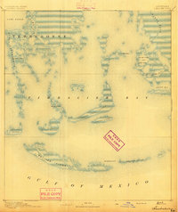
 1894 Lake Felicity1894 Print · USGSCoastal Louisiana in the early 1890s reveals a wild landscape of sprawling marshes and intricate bayous at the edge of the Gulf. Researchers can trace historic waterways like Bayou Du Chien and St. Jean Charles Bayou or locate Lake Billiot and Catfish Lake.3 unique versions available
 - 1894 Map of Dulac
 1894 Dulac1894 Print · USGSCoastal Terrebonne Parish appears here in the early 1890s, when life followed the natural rhythms of the bayous and marsh. Researchers can trace early water routes and family settlements near Montegut, Dulac, and the winding Bayou Grand Caillou.3 unique versions available
 - 1897 Map of Gibson
 1897 Gibson1897 Print · USGSCoastal Louisiana in the late nineteenth century was a world defined by its waterways and the rising influence of the rail. Genealogists and researchers can trace the early layout of bayou settlements like Schriever, Ellendale, and Chacahoula along the Southern Pacific Railroad.
End of results
Showing maps 1-14 of 14
Top cities of Lafourche Parish
Frequently asked questions
- What are the different types of historical maps available for Lafourche Parish?
- What is the oldest map of Lafourche Parish?
- Where can I purchase historical maps of Lafourche Parish for my home or office?
- Where can I download high-res historical maps of Lafourche Parish?
- Are there historical topographic maps available for Lafourche Parish?
- Is there historical aerial imagery available for Lafourche Parish?
- Where are historical maps of Lafourche Parish sourced from?