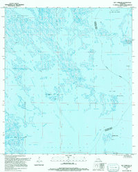
1994 Map of Bay Tambour
USGS Topo · Published 1994About this map
Bay Tambour and its surrounding wetlands represent the fragile, water-dominated environment of coastal Louisiana during the late twentieth century. This 1994 update reveals a landscape defined by an intricate network of bays, bayous, and lakes, such as Lake Enfermer and Caminada Bay, where land and water blur. The map highlights the significant role of the energy industry in this region, marking numerous active zones including the Fishermans Bay Gas Field and the Southwestern Louisiana Li Zette Bay Gas Field.
Find a feature on this map
36 named features on this map. Tap any name to fly to it.
Don’t see what you’re looking for? This feature index may not catch every label — zoom into the map to look around manually.
Map Details
Editions of this 1994 Bay Tambour Map
This is the sole edition of this map. No revisions or reprints were ever made.
Other maps of this area

1892 · Cheniere Caminada
USGS Topo · 1:62,500

1892 · Creole
USGS Topo · 1:62,500

1893 · Fort Livingston
USGS Topo · 1:62,500

1935 · Mink Bayou
USGS Topo · 1:31,680

1935 · Leeville
USGS Topo · 1:31,680

1935 · Wilkinson Bay
USGS Topo · 1:31,680

1945 · New Orleans
USGS Topo · 1:250,000

1945 · Leeville
USGS Topo · 1:31,680
1946 · Mink Bayou
USGS Topo · 1:31,680

1947 · Caminada Pass
USGS Topo · 1:31,680