
1945 Map of New Orleans
USGS Topo · Published 1945About this map
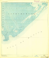
The Mississippi River and its intricate distributary networks anchor this mid-century portrait of southern Louisiana, stretching from the burgeoning urban core of New Orleans westward to the sugar parishes. The landscape is defined by the vital economic arteries of the Intracoastal Waterway and the Southern Pacific railroad, which connect industrial hubs like Morgan City and New Iberia. Inland, the map captures the transition from settled agricultural strips along Bayou Lafourche to the sprawling coastal wetlands, including the Russell Sage Wildlife Refuge and Game Preserve. To the south, the irregular coastline of Atchafalaya Bay and Terrebonne Bay reveals a complex world of islands and reefs, such as Point Au Fer Island and the Dernieres Isles, before the open waters of the Gulf of Mexico.
Find a feature on this map
117 named features on this map. Tap any name to fly to it.
Don’t see what you’re looking for? This feature index may not catch every label — zoom into the map to look around manually.
Map Details
Editions of this 1945 New Orleans Map
This is the sole edition of this map. No revisions or reprints were ever made.
Other maps of this area

1891 · Hahnville
USGS Topo · 1:62,500

1891 · Spanish Fort
USGS Topo · 1:62,500

1891 · Pointe a La Hache
USGS Topo · 1:62,500

1891 · New Orleans
USGS Topo · 1:62,500

1892 · Barataria
USGS Topo · 1:62,500
1892 · Cheniere Caminada
USGS Topo · 1:62,500

1892 · Lac Des Allemands
USGS Topo · 1:62,500

1892 · Chef Menteur
USGS Topo · 1:62,500

1892 · Mount Airy
USGS Topo · 1:62,500

1892 · Gibson
USGS Topo · 1:62,500