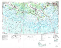
1963 Map of New Orleans
USGS Topo · Published 1980About this map
Mississippi River distributaries and the vast coastal wetlands of south Louisiana dominate this topographic and bathymetric study, which reveals the intricate drainage patterns of the mid-20th century. The transition from the sugar-cane-producing high ground along Bayou Teche near New Iberia to the marshy expanses of Marsh Island illustrates the region's historical reliance on elevated natural levees for settlement. In the east, the urban expansion around New Orleans and Marrero is clearly visible, while the southern coastal reaches are defined by a complex network of bays, including Timbalier Bay and Terrebonne Bay. This era shows the developed inland waterways around Morgan City and Houma, alongside the protected waters of the Shell Keys National Wildlife Refuge, capturing the landscape shortly after the expansion of offshore industry and regional drainage improvements.
Find a feature on this map
111 named features on this map. Tap any name to fly to it.
Don’t see what you’re looking for? This feature index may not catch every label — zoom into the map to look around manually.
Map Details
Editions of this 1963 New Orleans Map
4 editions found

Other maps of this area

1891 · Hahnville
USGS Topo · 1:62,500

1891 · Spanish Fort
USGS Topo · 1:62,500

1891 · Pointe a La Hache
USGS Topo · 1:62,500

1891 · New Orleans
USGS Topo · 1:62,500

1892 · Barataria
USGS Topo · 1:62,500

1892 · Cheniere Caminada
USGS Topo · 1:62,500

1892 · Lac Des Allemands
USGS Topo · 1:62,500

1892 · Chef Menteur
USGS Topo · 1:62,500

1892 · Mount Airy
USGS Topo · 1:62,500

1892 · Gibson
USGS Topo · 1:62,500