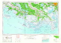
1963 Map of New Orleans
USGS Topo · Published 1963About this map
The Mississippi River and a labyrinth of bayous define this expansive coastal landscape in the mid-20th century. Major hubs like New Iberia, Morgan City, and Houma serve as anchors for the region's unique wetland economy, where industry and transportation are inextricably linked to the water. The Southern Pacific and Texas and Pacific railroads parallel the natural curves of Bayou Teche and other waterways, connecting agricultural and maritime settlements such as Jeanerette and Thibodaux. South of the inhabited marshes, the map reveals the complex shoreline of Atchafalaya Bay and the protective barrier of the Isles Dernieres. Conservation efforts are evident at the Russell Sage Wildlife Refuge and Game Preserve, while the extensive parish boundaries illustrate the administrative complexity of managing these shifting, water-dominant territories during an era of significant coastal activity.
Find a feature on this map
89 named features on this map. Tap any name to fly to it.
Don’t see what you’re looking for? This feature index may not catch every label — zoom into the map to look around manually.
Map Details
Editions of this 1963 New Orleans Map
4 editions found

Other maps of this area

1891 · Hahnville
USGS Topo · 1:62,500

1891 · Spanish Fort
USGS Topo · 1:62,500

1891 · Pointe a La Hache
USGS Topo · 1:62,500

1891 · New Orleans
USGS Topo · 1:62,500

1892 · Barataria
USGS Topo · 1:62,500

1892 · Cheniere Caminada
USGS Topo · 1:62,500

1892 · Lac Des Allemands
USGS Topo · 1:62,500

1892 · Chef Menteur
USGS Topo · 1:62,500

1892 · Mount Airy
USGS Topo · 1:62,500

1892 · Gibson
USGS Topo · 1:62,500