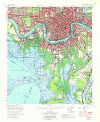
1967 Map of New Orleans
USGS Topo · Published 1969About this map
The Mississippi River defines the geometry of this 1960s study, looping through the crescent of New Orleans and south toward the Gulf. The city’s dense urban grid, featuring landmarks like Tulane University, Loyola University, and the sprawling Metairie Cemetery, contrasts sharply with the expansive wetlands of Lake Cataouatche and Lake Salvador to the southwest. This era captures the industrial and military footprint of the river’s west bank, from the massive Avondale Oil Field to the U.S. Naval Air Station (Alvin Callender Field).
Find a feature on this map
81 named features on this map. Tap any name to fly to it.
Don’t see what you’re looking for? This feature index may not catch every label — zoom into the map to look around manually.
Map Details
Editions of this 1967 New Orleans Map
This is the sole edition of this map. No revisions or reprints were ever made.
Other maps of this area

1891 · Hahnville
USGS Topo · 1:62,500

1891 · Spanish Fort
USGS Topo · 1:62,500

1891 · Pointe a La Hache
USGS Topo · 1:62,500

1891 · New Orleans
USGS Topo · 1:62,500

1892 · Barataria
USGS Topo · 1:62,500

1892 · Chef Menteur
USGS Topo · 1:62,500

1892 · Bonnet Carre
USGS Topo · 1:62,500

1892 · Cut-Off
USGS Topo · 1:62,500

1892 · St. Bernard
USGS Topo · 1:62,500

1892 · Pointe a La Hache
USGS Topo · 1:62,500