
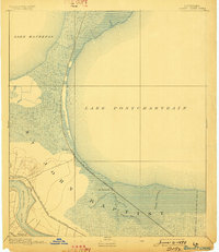
1892 Map of Bonnet Carre
USGS Topo · Published 1892About this map
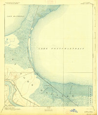
The Mississippi River and the vast waters of Lake Pontchartrain dominate this late nineteenth-century delta landscape, which is defined by the tension between river commerce and the low-lying wetlands. The presence of the Bonnet Carre Crevasse indicates the persistent threat of river flooding that shaped local geography long before the modern spillway era. On the narrow strip of land between the river and the lake, settlements like Bonnet Carre, Lucy, and Freetown grew alongside early rail networks including the Louisville New Orleans and Texas Railroad. To the north, the Chicago St. Louis and New Orleans Railroad hugs the lakefront, passing through isolated outposts like Frenier and La Branche surrounded by complex drainage systems like Bayou Trepagnier and Bayou La Branche.
Find a feature on this map
18 named features on this map. Tap any name to fly to it.
Don’t see what you’re looking for? This feature index may not catch every label — zoom into the map to look around manually.
Map Details
Editions of this 1892 Bonnet Carre Map
3 editions found
Other maps of this area

1891 · Hahnville
USGS Topo · 1:62,500

1891 · Spanish Fort
USGS Topo · 1:62,500

1891 · New Orleans
USGS Topo · 1:62,500

1892 · Lac Des Allemands
USGS Topo · 1:62,500

1892 · Mount Airy
USGS Topo · 1:62,500

1932 · New Orleans NW
USGS Topo · 1:31,680

1932 · Hahnville NW
USGS Topo · 1:31,680

1932 · Lac Des Allemands NE
USGS Topo · 1:31,680

1932 · Hahnville NE
USGS Topo · 1:31,680

1934 · Springfield
USGS Topo · 1:62,500