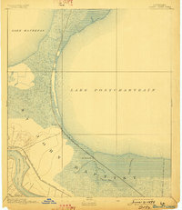
1892 Map of Bonnet Carre
USGS Topo · Published 1898About this map
St. John Baptist Parish is defined by its precarious and vital relationship with the water in the late nineteenth century. The western shore of Lake Pontchartrain dominates the landscape, where the Chicago St. Louis and New Orleans Railroad tracks hug the shoreline through the marshy lowlands near Frenier. This survey illustrates the riverfront settlements of Lucy and Freetown along the Mississippi River, contrasting the stable river landings with the dynamic environment of the Bonnet Carre Crevasse. The rail network, including the Louisville New Orleans and Texas Railroad, follows the natural levees, while the interior is a maze of waterways like Bayou Trepagnier and Bayou Traverse. These features reveal an era of intense engineering efforts to manage the river's floods and connect the New Orleans hinterland to national markets.
Find a feature on this map
18 named features on this map. Tap any name to fly to it.
Don’t see what you’re looking for? This feature index may not catch every label — zoom into the map to look around manually.
Map Details
Editions of this 1892 Bonnet Carre Map
3 editions found
Other maps of this area

1891 · Hahnville
USGS Topo · 1:62,500

1891 · Spanish Fort
USGS Topo · 1:62,500

1891 · New Orleans
USGS Topo · 1:62,500

1892 · Lac Des Allemands
USGS Topo · 1:62,500

1892 · Mount Airy
USGS Topo · 1:62,500

1892 · Bonnet Carre
USGS Topo · 1:62,500

1932 · New Orleans NW
USGS Topo · 1:31,680

1932 · Hahnville NW
USGS Topo · 1:31,680

1932 · Lac Des Allemands NE
USGS Topo · 1:31,680

1932 · Hahnville NE
USGS Topo · 1:31,680