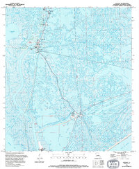
1994 Map of Leeville
USGS Topo · Published 1994About this map
Bayou Lafourche serves as the central artery for this coastal landscape, where the town of Leeville and its associated industrial infrastructure define the local economy. The Leeville Oil and Gas Field dominates the northern section, evidenced by a dense network of radio towers, substations, and a Heliport that support offshore and marsh operations. A small Cem near Leeville provides a point of interest for genealogists tracing local families in this specialized maritime environment. Further south, Pointe Fourchon marks a critical transition towards the Gulf of Mexico, with the Port Fourchon Water Tank anchoring a region defined by man-made waterways like the Louisiana Canal and Flotation Canal. These canals reveal the extensive engineering required to navigate and extract resources from the shifting marshlands between Timbalier Bay and Lake Laurier.
Find a feature on this map
31 named features on this map. Tap any name to fly to it.
Don’t see what you’re looking for? This feature index may not catch every label — zoom into the map to look around manually.
Map Details
Editions of this 1994 Leeville Map
This is the sole edition of this map. No revisions or reprints were ever made.
Other maps of this area

1892 · Cheniere Caminada
USGS Topo · 1:62,500

1892 · Creole
USGS Topo · 1:62,500

1894 · Timbalier
USGS Topo · 1:62,500

1894 · Lake Felicity
USGS Topo · 1:62,500

1935 · Bay Courant
USGS Topo · 1:31,680

1935 · Pelican Pass
USGS Topo · 1:31,680

1935 · Mink Bayou
USGS Topo · 1:31,680

1935 · Calumet Island
USGS Topo · 1:31,680

1935 · Leeville
USGS Topo · 1:31,680

1939 · Lake Felicity
USGS Topo · 1:62,500