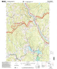
1996 Map of Quechee
USGS Topo · Published 2000About this map
The Ottauquechee River carves through the landscape of Windsor County, creating the dramatic Quechee Gorge and powering the industrial heritage at Deweys Mills. In the mid-1990s, this area reflects a blend of historic valley settlements and protected woodlands, with a significant portion of the Green Mountain National Forest spanning the western hills. The map highlights the intersection of modern recreation and colonial-era routes, including segments of The Kings Highway and the Thistle Hill Shelter along the Appalachian Trail corridor. Genealogists will find a high density of preserved burial grounds, from the Murphy Cem near the White River to the Centertown Cem and Savage Cem. The documentation of a Covered Bridge at Taftsville and a Historical Monument near Quechee illustrates the region's commitment to preserving its architectural and civic past.
Find a feature on this map
63 named features on this map. Tap any name to fly to it.
Don’t see what you’re looking for? This feature index may not catch every label — zoom into the map to look around manually.
Map Details
Editions of this 1996 Quechee Map
This is the sole edition of this map. No revisions or reprints were ever made.
Other maps of this area

1896 · Strafford
USGS Topo · 1:62,500

1906 · Hanover
USGS Topo · 1:62,500

1908 · Hanover
USGS Topo · 1:62,500

1911 · Woodstock
USGS Topo · 1:62,500

1913 · Woodstock
USGS Topo · 1:62,500

1919 · Royalton
USGS Topo · 1:62,500

1924 · Randolph
USGS Topo · 1:48,000

1926 · Randolph
USGS Topo · 1:62,500

1943 · Woodstock
USGS Topo · 1:62,500

1944 · Strafford
USGS Topo · 1:62,500