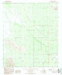
1989 Map of Queens Well
USGS Topo · Published 1989About this map
The Papago Indian Reservation dominates this desert landscape, where the seasonal waters of Aguirre Wash cut through the broad Aguirre Valley. In this arid terrain, human adaptation is visible through the extensive network of Check Dams and isolated water sources like the eponymous Queens Well. The map captures a moment of late-century land management, reflecting the infrastructure required for subsistence and ranching in a remote corner of Pima County. Topographic relief is provided by the Vaca Hills to the west and the prominent Ka Kohl Hill rising in the northeast. This 1989 edition, based on earlier surveys and updated with 1980s aerial photography, provides a detailed record of the desert's drainage patterns and the specific, named landmarks that defined this tribal land before the reservation's formal renaming.
Find a feature on this map
10 named features on this map. Tap any name to fly to it.
Don’t see what you’re looking for? This feature index may not catch every label — zoom into the map to look around manually.
Map Details
Editions of this 1989 Queens Well Map
This is the sole edition of this map. No revisions or reprints were ever made.
Other maps of this area

1934 · Silver Bell
USGS Topo · 1:125,000

1937 · Comobabi
USGS Topo · 1:48,000

1938 · San Vicente
USGS Topo · 1:62,500

1941 · San Vicente
USGS Topo · 1:62,500

1942 · San Vicente
USGS Topo · 1:62,500

1942 · Comobabi
USGS Topo · 1:62,500

1948 · San Vicente
USGS Topo · 1:62,500

1956 · Tucson
USGS Topo · 1:250,000

1958 · Tucson
USGS Topo · 1:250,000

1959 · Tucson
USGS Topo · 1:250,000