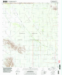
1996 Map of Queens Well
USGS Topo · Published 2003About this map
The Tohono O'odham Indian Reservation covers the majority of this desert landscape, where water sources and topographic landmarks defined local movement in the late twentieth century. Centered on the Aguirre Valley, the terrain is marked by the prominent drainage of Aguirre Wash flowing north through the arid basin. To the southwest, the elevated terrain of the Vaca Hills provides a stark contrast to the valley floor, while Ka Kohl Hill rises in the northeast. Human presence is anchored by the eponymous Queens Well and the San Ignacio Ranch, connected by a network of unimproved 4 WD tracks. A northern strip of the map falls within the Ironwood Forest National Monument, illustrating the transition from tribal lands to federal conservation areas.
Find a feature on this map
23 named features on this map. Tap any name to fly to it.
Don’t see what you’re looking for? This feature index may not catch every label — zoom into the map to look around manually.
Map Details
Editions of this 1996 Queens Well Map
This is the sole edition of this map. No revisions or reprints were ever made.
Other maps of this area

1934 · Silver Bell
USGS Topo · 1:125,000

1937 · Comobabi
USGS Topo · 1:48,000

1938 · San Vicente
USGS Topo · 1:62,500

1941 · San Vicente
USGS Topo · 1:62,500

1942 · San Vicente
USGS Topo · 1:62,500

1942 · Comobabi
USGS Topo · 1:62,500

1948 · San Vicente
USGS Topo · 1:62,500

1956 · Tucson
USGS Topo · 1:250,000

1958 · Tucson
USGS Topo · 1:250,000

1959 · Tucson
USGS Topo · 1:250,000